Nevada State Route 787
State Route 787 (SR 787) is a very short state highway along a section of Hanson Street in Winnemucca, Nevada, United States. SR 787 primarily serves as a connector road between Interstate 80 Business/U.S. Route 95 (I‑80 Bus./US 95) and State Route 294 (SR 294) within the city.
| ||||
|---|---|---|---|---|
| Hanson Street | ||||

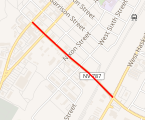
SR 787 highlighted in red | ||||
| Route information | ||||
| Maintained by NDOT | ||||
| Length | 0.497 mi[1] (0.800 km) | |||
| Major junctions | ||||
| West end | ||||
| East end | ||||
| Location | ||||
| Counties | Humboldt | |||
| Highway system | ||||
| ||||
Route description
SR 787 begins at an intersection with West Winnemucca Drive (I‑80 Bus./US 95). (Hanson Street continues northwest a block before ending at the southwestern end of West 2nd Street. West Winnemucca Boulevard [I‑80 Bus./US 95] continues southwest to an interchange with Interstate 80 [I‑80] and northwest to both a junction with State Route 289 and then another interchange with I‑80.) From its western terminus, SR 787 heads southeast as a three lane road (with a center turn lane) through commercial area for the entire length of the route.
After crossing West 4th Street, SR 787 connects with the southwest end of West 5th Street and then crosses Nixon Street and West 6th Street. The route then traverses a viaduct (that passes over the Union Pacific Railroad tracks) before reaching its eastern terminus at an intersection with Grass Valley Road (SR 294)/West Haskell Street. (From the southern terminus of SR 787, Hanson Street continues easterly before ending at an intersection with South Highland Drive and Water Canyon Road. West Haskell Street heads northeast, running parallel with the southwest side of the railroad tracks, to East Winnemucca Boulevard [I‑80 Bus./SR 794], after which East Haskell Street becomes Fairgrounds Road. Grass Valley Road [SR 294] heads southwest [leaving Winnemucca] to point about 1.75 miles [2.82 km] east-northeast of the Winnemucca Municipal Airport. From that point Grass Valley Road heads southerly through the Grass Valley, passing the community of Grass Valley, and on to the southern part of Pleasant Valley. However, SR 294 terminates at the Pershing County line, at the intersection of Grass Valley Road with Power Line Road/Muddy Road, about 8 miles [13 km] south of Winnemucca.)
Major intersections
The entire route is in Winnemucca, Humboldt County.
| mi[1] | km | Destinations | Notes | ||
|---|---|---|---|---|---|
| 0.000 | 0.000 | Hanson Street (northwest) – West 2nd Street | Continuation northwest beyond western terminus | ||
| Western terminus | |||||
| Viaduct over the Union Pacific Railroad tracks | |||||
| 0.497 | 0.800 | West Haskell Street (north) – SR 794 / I‑80 Bus. | Eastern terminus SR 294 formerly continued north along West Haskell Street | ||
| Hanson Street (east) – South Highland Drive and Water Canyon Road | Continuation southeast beyond eastern terminus | ||||
| 1.000 mi = 1.609 km; 1.000 km = 0.621 mi | |||||
References
- "State Maintained Highways of Nevada: Descriptions and Maps". nevadadot.com. Nevada Department of Transportation. Jan 2017. Retrieved 13 Jan 2017.
External links
![]()
