Neoga Township, Cumberland County, Illinois
Neoga Township is one of eight townships in Cumberland County, Illinois, USA. As of the 2010 census, its population was 3,124 and it contained 1,371 housing units.[2]
Neoga Township | |
|---|---|
 Location in Cumberland County | |
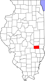 Cumberland County's location in Illinois | |
| Coordinates: 39°19′N 88°24′W | |
| Country | |
| State | |
| County | Cumberland |
| Established | November 6, 1860 |
| Area | |
| • Total | 55.5 sq mi (144 km2) |
| • Land | 54.68 sq mi (141.6 km2) |
| • Water | 0.81 sq mi (2.1 km2) 1.46% |
| Elevation | 676 ft (206 m) |
| Population (2010) | |
| • Estimate (2016)[1] | 3,064 |
| • Density | 57.1/sq mi (22.0/km2) |
| Time zone | UTC-6 (CST) |
| • Summer (DST) | UTC-5 (CDT) |
| ZIP codes | 62447, 62468, 62469 |
| FIPS code | 17-035-51993 |
Geography
According to the 2010 census, the township has a total area of 55.5 square miles (144 km2), of which 54.68 square miles (141.6 km2) (or 98.52%) is land and 0.81 square miles (2.1 km2) (or 1.46%) is water.[2]
Cities, towns, villages
Unincorporated towns
Cemeteries
The township contains these eight cemeteries: Concord, Drummond, Illinois Central Railroad, Lockhart, Long Point, Neoga, Neoga Railroad Crossing and Zion.
Major highways
Airports and landing strips
- Cumberland Air Park
- Williamson Airport
School districts
- Cumberland Community Unit School District 77
- Mattoon Community Unit School District 2
- Neoga Community Unit School District 3
Political districts
- State House District 109
- State Senate District 55
gollark: That was literally ubq's idea some minutes ago.
gollark: It WAS 4/5, apio.
gollark: Done.
gollark: <@!293066066605768714> join then leave it and go consume food
gollark: * and eat
References
- "Neoga Township, Cumberland County, Illinois". Geographic Names Information System. United States Geological Survey. Retrieved 2010-01-17.
- United States Census Bureau 2009 TIGER/Line Shapefiles
- United States National Atlas
- "Population and Housing Unit Estimates". Retrieved June 9, 2017.
- "Population, Housing Units, Area, and Density: 2010 - County -- County Subdivision and Place -- 2010 Census Summary File 1". United States Census. Archived from the original on 2020-02-12. Retrieved 2013-05-28.
- "Census of Population and Housing". Census.gov. Retrieved June 4, 2016.
External links
Adjacent townships
Places adjacent to Neoga Township, Cumberland County, Illinois | |
|---|---|
Municipalities and communities of Cumberland County, Illinois, United States | ||
|---|---|---|
| Cities | Map of Illinois highlighting Cumberland County | |
| Villages | ||
| Townships | ||
| Unincorporated communities | ||
| Footnotes | ‡This populated place also has portions in an adjacent county or counties | |
This article is issued from Wikipedia. The text is licensed under Creative Commons - Attribution - Sharealike. Additional terms may apply for the media files.