National Register of Historic Places listings in Roberts County, South Dakota
This is a list of the National Register of Historic Places listings in Roberts County, South Dakota.
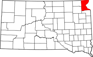
Location of Roberts County in South Dakota
This is intended to be a complete list of the properties and districts on the National Register of Historic Places in Roberts County, South Dakota, United States. The locations of National Register properties and districts for which the latitude and longitude coordinates are included below, may be seen in a map.[1]
There are 11 properties and districts listed on the National Register in the county.
- This National Park Service list is complete through NPS recent listings posted August 14, 2020.[2]
Current listings
| [3] | Name on the Register[4] | Image | Date listed[5] | Location | City or town | Description |
|---|---|---|---|---|---|---|
| 1 | Hart School No. 3 | 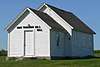 Hart School No. 3 |
August 16, 2000 (#00000994) |
Route 1 45°45′14″N 96°53′47″W |
Sisseton | |
| 2 | Knapp Ranch | 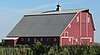 Knapp Ranch |
April 14, 2005 (#05000282) |
13168 450th Avenue 45°28′33″N 97°12′18″W |
Ortley | |
| 3 | New Effington Hospital | 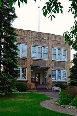 New Effington Hospital |
July 13, 1989 (#89000829) |
Oddin Avenue 45°51′14″N 96°55′05″W |
New Effington | |
| 4 | New Effington Rest Stop Tipi | 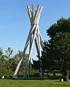 New Effington Rest Stop Tipi |
January 14, 2015 (#14001189) |
Mile 250.8 on I-29 45°54′29″N 96°51′51″W |
New Effington | |
| 5 | Robar Trading Post |  Robar Trading Post |
May 27, 1988 (#88000582) |
Address Restricted |
Wilmot | |
| 6 | Roberts County Courthouse | 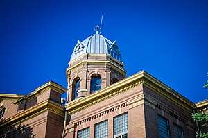 Roberts County Courthouse |
December 12, 1976 (#76001755) |
411 Second Avenue East[6] 45°39′47″N 97°02′41″W |
Sisseton | |
| 7 | Sisseton Carnegie Library | 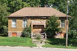 Sisseton Carnegie Library |
October 24, 1996 (#96001227) |
215 Oak Street, East 45°39′54″N 97°02′51″W |
Sisseton | |
| 8 | Site 39RO71 | Site 39RO71 |
June 8, 2005 (#05000588) |
Address Restricted |
Sisseton | |
| 9 | South Dakota Department of Transportation Bridge No. 55-030-418 |  South Dakota Department of Transportation Bridge No. 55-030-418 |
December 9, 1999 (#99001437) |
State railroad tracks over a local road 45°19′49″N 97°09′55″W |
Ortley | |
| 10 | Andrew and Mary Stavig House | 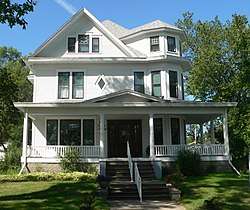 Andrew and Mary Stavig House |
November 7, 1997 (#97001392) |
112 First Avenue, West 45°39′41″N 97°03′09″W |
Sisseton | |
| 11 | Walla Lutheran Church | 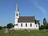 Walla Lutheran Church |
May 19, 2004 (#04000470) |
46532 105th Street 45°51′56″N 96°53′22″W |
New Effington |
gollark: Is there a way to chain together the results you get?
gollark: Well, it's an interesting idea, but it sounds like it would run slowly.
gollark: https://github.com/drathier/stack-overflow-import
gollark: Oh, so like the Python "import from Stack Overflow" thing.
gollark: Or you could use Turi, my other other esolang: https://esolangs.org/wiki/Turi
See also
| Wikimedia Commons has media related to National Register of Historic Places in Roberts County, South Dakota. |
References
- The latitude and longitude information provided in this table was derived originally from the National Register Information System, which has been found to be fairly accurate for about 99% of listings. Some locations in this table may have been corrected to current GPS standards.
- "National Register of Historic Places: Weekly List Actions". National Park Service, United States Department of the Interior. Retrieved on August 14, 2020.
- Numbers represent an ordering by significant words. Various colorings, defined here, differentiate National Historic Landmarks and historic districts from other NRHP buildings, structures, sites or objects.
- "National Register Information System". National Register of Historic Places. National Park Service. April 24, 2008.
- The eight-digit number below each date is the number assigned to each location in the National Register Information System database, which can be viewed by clicking the number.
- "Roberts County". South Dakota Unified Judicial System. Retrieved September 15, 2017.
| Topics | |
|---|---|
| Lists by state |
|
| Lists by insular areas | |
| Lists by associated state | |
| Other areas | |
| Related | |
| |
Municipalities and communities of Roberts County, South Dakota, United States | ||
|---|---|---|
| Cities | | |
| Towns | ||
| CDPs | ||
| Townships | ||
| Unincorporated community | ||
| Indian reservation | ||
| Footnotes | ‡This populated place also has portions in an adjacent county or counties | |
This article is issued from Wikipedia. The text is licensed under Creative Commons - Attribution - Sharealike. Additional terms may apply for the media files.