National Register of Historic Places listings in Park County, Wyoming
This is a list of the National Register of Historic Places listings in Park County, Wyoming.
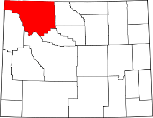
Location of Park County in Wyoming
This is intended to be a complete list of the properties and districts on the National Register of Historic Places in Park County, Wyoming, United States. The locations of National Register properties and districts for which the latitude and longitude coordinates are included below, may be seen in a map.[1]
There are 41 properties and districts listed on the National Register in the county, 6 of which are National Historic Landmarks.
- This National Park Service list is complete through NPS recent listings posted August 14, 2020.[2]
| Albany - Big Horn - Campbell - Carbon - Converse - Crook - Fremont - Goshen - Hot Springs - Johnson - Laramie - Lincoln - Natrona - Niobrara - Park - Platte - Sheridan - Sublette - Sweetwater - Teton - Uinta - Washakie - Weston |
Current listings
| [3] | Name on the Register | Image | Date listed[4] | Location | City or town | Description |
|---|---|---|---|---|---|---|
| 1 | Absaroka Mountain Lodge |  Absaroka Mountain Lodge |
October 30, 2003 (#03001105) |
1231 North Fork Highway 44°27′26″N 109°47′25″W |
Cody | |
| 2 | Anderson Lodge |  Anderson Lodge |
September 14, 1987 (#87001548) |
Greybull Ranger District, Shoshone National Forest 44°06′06″N 109°25′56″W |
Meeteetse | |
| 3 | Quintin Blair House | September 27, 1991 (#91000998) |
5588 Greybull Highway 44°30′34″N 109°00′05″W |
Cody | ||
| 4 | Buffalo Bill Boyhood Home | %2C_Le_Claire%2C_Scott%2C_IA.jpg) Buffalo Bill Boyhood Home |
June 5, 1975 (#75001906) |
720 Sheridan Ave. 44°31′27″N 109°04′25″W |
Cody | |
| 5 | Buffalo Bill Dam | 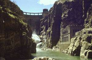 Buffalo Bill Dam |
August 12, 1971 (#71000890) |
7 miles west of Cody 44°30′05″N 109°10′57″W |
Cody | |
| 6 | Buffalo Bill Statue | 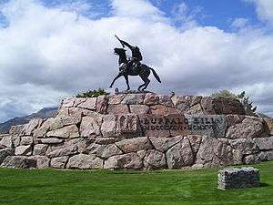 Buffalo Bill Statue |
December 31, 1974 (#74002319) |
720 Sheridan Ave. 44°31′33″N 109°04′26″W |
Cody | |
| 7 | Clay Butte Lookout | 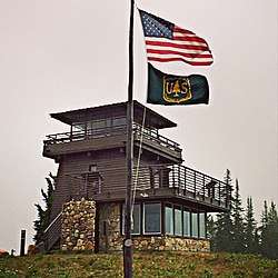 Clay Butte Lookout |
January 8, 2014 (#13001065) |
Approx. 1/2 mi. N. of jct. of US 212 and FS Rd. 142 44°56′40″N 109°37′36″W |
Clark vicinity | Fire lookout tower built 1941-43, started by the Civilian Conservation Corps |
| 8 | Colter's Hell | 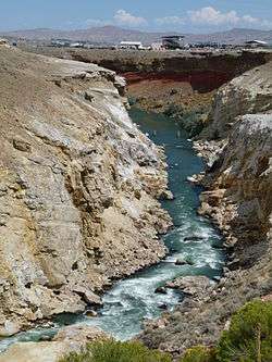 Colter's Hell |
August 14, 1973 (#73001937) |
West of Cody on U.S. Route 14 44°30′53″N 109°07′02″W |
Cody | A square mile of steam vents and hot springs on the Shoshone River. When John Colter saw it in 1807, it had active geysers. His account of that visit was the first description by a white man of a place in Wyoming.[5] |
| 9 | Dead Indian Campsite | May 3, 1974 (#74002030) |
Sunlight Basin Road[6] |
Cody | ||
| 10 | Downtown Cody Historic District |  Downtown Cody Historic District |
August 15, 1983 (#83003361) |
1155 to 1313 and 1192 to 1286 Sheridan Ave. 44°31′34″N 109°04′21″W |
Cody | |
| 11 | Elephant Head Lodge | October 30, 2003 (#03001107) |
1170 North Fork Highway 44°27′18″N 109°48′13″W |
Cody | ||
| 12 | First National Bank of Meeteetse |  First National Bank of Meeteetse |
September 5, 1990 (#90001388) |
1033 Park Ave. 44°09′25″N 108°52′21″W |
Meeteetse | |
| 13 | Fort Yellowstone |  Fort Yellowstone |
July 31, 2003 (#03001032) |
Mammoth Hot Springs and Norris, Wyoming; Gardiner, Montana, near Buffalo Lake, Idaho 44°58′30″N 110°41′53″W |
Mammoth Hot Springs | |
| 14 | Goff Creek Lodge | October 30, 2003 (#03001108) |
995 E. Yellowstone Highway 44°27′19″N 109°50′12″W |
Cody | ||
| 15 | Grand Loop Road Historic District | 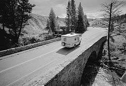 Grand Loop Road Historic District |
December 23, 2003 (#03001345) |
Grand Loop Rd. 44°38′16″N 110°36′54″W |
Yellowstone National Park | |
| 16 | Hayden Arch Bridge |  Hayden Arch Bridge |
February 22, 1985 (#85000430) |
Old US Routes 14/16 (Cody Yellowstone Highway) 44°30′37″N 109°08′48″W |
Cody | |
| 17 | Heart Mountain Relocation Center |  Heart Mountain Relocation Center |
December 19, 1985 (#85003167) |
½ mile from Wyoming Alt. 14 between Cody and Powell/1500 Road 19 44°40′14″N 108°56′35″W |
Ralston | |
| 18 | Horner Site | October 15, 1966 (#66000758) |
On a bluff overlooking the confluence of Sage Creek and the Shoshone River, 5 miles (8.0 km) east of Cody[7] 44°33′21″N 108°59′39″W |
Cody | ||
| 19 | Irma Hotel |  Irma Hotel |
April 3, 1973 (#73001936) |
1192 Sheridan Ave. 44°31′35″N 109°03′26″W |
Cody | |
| 20 | Lamar Buffalo Ranch |  Lamar Buffalo Ranch |
December 7, 1982 (#82001835) |
East of Mammoth Hot Springs on Northeast Entrance Rd. 44°53′32″N 110°14′23″W |
Mammoth Hot Springs | |
| 21 | Mammoth Hot Springs Historic District |  Mammoth Hot Springs Historic District |
March 20, 2002 (#02000257) |
North Entrance Rd. and Mammoth-Norris Rd. 44°58′37″N 110°41′52″W |
Yellowstone National Park | |
| 22 | Mummy Cave |  Mummy Cave |
February 18, 1981 (#81000611) |
U.S. Routes 14/16/20 near the eastern entrance of Yellowstone National Park[8] 44°27′39″N 109°44′10″W |
Cody | |
| 23 | Norris Museum/Norris Comfort Station |  Norris Museum/Norris Comfort Station |
July 21, 1983 (#83003362) |
Grand Loop Rd. 44°43′34″N 110°42′21″W |
Yellowstone National Park | |
| 24 | Norris, Madison, and Fishing Bridge Museums |  Norris, Madison, and Fishing Bridge Museums |
May 28, 1987 (#87001445) |
Norris Geyser Basin, Madison Junction, and Fishing Bridge 44°38′38″N 110°38′49″W |
Yellowstone National Park | |
| 25 | North Entrance Road Historic District |  North Entrance Road Historic District |
May 22, 2002 (#02000530) |
Yellowstone National Park 45°00′24″N 110°41′58″W |
Yellowstone National Park | |
| 26 | Obsidian Cliff |  Obsidian Cliff |
June 19, 1996 (#96000973) |
Approximately 13 miles south of Mammoth; eastern side of U.S. Route 89, south of Obsidian Cliff Kiosk 44°48′28″N 110°41′52″W |
Mammoth | |
| 27 | Obsidian Cliff Kiosk |  Obsidian Cliff Kiosk |
July 9, 1982 (#82001719) |
Yellowstone National Park 44°49′20″N 110°44′02″W |
Mammoth | |
| 28 | Pagoda Creek | December 22, 2017 (#100001914) |
Address Restricted |
Wapiti | ||
| 29 | Pahaska Tepee |  Pahaska Tepee |
March 20, 1973 (#73001938) |
2 miles east of eastern entrance to Yellowstone National Park on U.S. Route 14 44°30′10″N 109°57′42″W |
Cody | |
| 30 | Pioneer School | October 5, 1993 (#93001011) |
County Road 1-AG north of Badger Basin 44°58′23″N 109°05′00″W |
Clark | ||
| 31 | Ralston Community Clubhouse |  Ralston Community Clubhouse |
July 23, 1998 (#98000907) |
969 Carbon St. 44°43′11″N 108°52′05″W |
Ralston | |
| 32 | Red Lodge-Cooke City Approach Road Historic District | 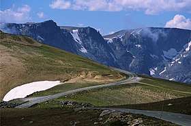 Red Lodge-Cooke City Approach Road Historic District |
May 8, 2014 (#14000219) |
US 212 44°56′31″N 109°35′47″W |
Red Lodge | Extends into Carbon County, Montana and Park County, Montana |
| 33 | Red Star Lodge and Sawmill | October 30, 2003 (#03001106) |
349 Yellowstone Highway 44°29′49″N 109°56′04″W |
Cody | ||
| 34 | Roosevelt Lodge Historic District | 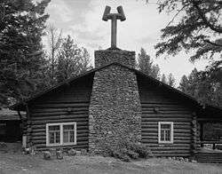 Roosevelt Lodge Historic District |
April 4, 1983 (#83003363) |
Grand Loop Rd. 44°54′47″N 110°24′56″W |
Yellowstone National Park | |
| 35 | Stock Center |  Stock Center |
January 1, 1976 (#76001960) |
836 Sheridan Ave. 44°31′31″N 109°04′11″W |
Cody | |
| 36 | Paul Stock House | 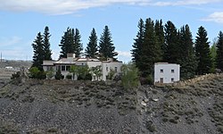 Paul Stock House |
January 27, 2000 (#99001727) |
1300 Sunset Dr. 44°31′24″N 109°04′50″W |
Cody | |
| 37 | T E Ranch Headquarters | April 3, 1973 (#73001939) |
30 miles southwest of Cody on South Fork Rd. 44°16′53″N 109°29′35″W |
Cody | ||
| 38 | US Post Office-Powell Main |  US Post Office-Powell Main |
May 22, 1987 (#87000787) |
270 N. Bent St. 44°45′19″N 108°45′27″W |
Powell | |
| 39 | US Post Office-Yellowstone Main |  US Post Office-Yellowstone Main |
May 19, 1987 (#87000789) |
Mammoth, off Grand Loop Rd. 44°58′37″N 110°41′52″W |
Yellowstone National Park | |
| 40 | UXU Ranch | May 24, 2003 (#03000581) |
1710 N. Fork Highway, Shoshone National Forest 44°09′18″N 109°43′15″W |
Wapiti | ||
| 41 | Wapiti Ranger Station | 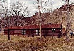 Wapiti Ranger Station |
October 15, 1966 (#66000759) |
Shoshone National Forest 44°27′57″N 109°36′58″W |
Wapiti |
gollark: It seems to be piephon.
gollark: It's basically a reflection of the fact that Java is bad and Kotlin less bad.
gollark: Should it not be a node tree, anyway?
gollark: Can you recommend a different way to keep the weird vector-of-node thing?
gollark: <@337621533369303042> I guess you want that then if you *must* be C++y and evil.
See also
| Wikimedia Commons has media related to National Register of Historic Places in Park County, Wyoming. |
References
- The latitude and longitude information provided in this table was derived originally from the National Register Information System, which has been found to be fairly accurate for about 99% of listings. Some locations in this table may have been corrected to current GPS standards.
- "National Register of Historic Places: Weekly List Actions". National Park Service, United States Department of the Interior. Retrieved on August 14, 2020.
- Numbers represent an ordering by significant words. Various colorings, defined here, differentiate National Historic Landmarks and historic districts from other NRHP buildings, structures, sites or objects.
- The eight-digit number below each date is the number assigned to each location in the National Register Information System database, which can be viewed by clicking the number.
- Frost, Ned. "Colter's Hell". National Register of Historic Places -Inventory Nomination Form. National Park Service. Retrieved 2013-09-07.
- Location derived from this Wyoming State Historic Preservation Office webpage; the NRIS lists the site as "Address Restricted".
- Location derived from pages 179, 180, and 182 of this document; the NRIS lists the site as "Address Restricted"
- Location derived from this Wyoming State Historic Preservation Office webpage and from Husted, Wilfred M., and Robert Edgar. The Archeology of Mummy Cave, Wyoming: An Introduction to Shoshonean Prehistory, page xii. Midwest Archeological Center and Southeast Archeological Center via the National Park Service, 2002. Accessed 2009-07-29. The NRIS lists the site as "Address Restricted"
| Topics | |
|---|---|
| Lists by state |
|
| Lists by insular areas | |
| Lists by associated state | |
| Other areas | |
| Related | |
| |
Municipalities and communities of Park County, Wyoming, United States | ||
|---|---|---|
| Cities | | |
| Towns | ||
| CDPs | ||
| Unincorporated communities | ||
| Ghost town | ||
| Footnotes | ‡This populated place also has portions in an adjacent county or counties | |
This article is issued from Wikipedia. The text is licensed under Creative Commons - Attribution - Sharealike. Additional terms may apply for the media files.