National Register of Historic Places listings in McDowell County, West Virginia
This is a list of the National Register of Historic Places listings in McDowell County, West Virginia.
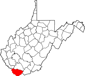
This is intended to be a complete list of the properties and districts on the National Register of Historic Places in McDowell County, West Virginia, United States. The locations of National Register properties and districts for which the latitude and longitude coordinates are included below, may be seen in an online map.[1]
There are 17 properties and districts listed on the National Register in the county. Most of these locations are the former company stores of coal companies.
- This National Park Service list is complete through NPS recent listings posted August 14, 2020.[2]
Barbour - Berkeley - Boone - Braxton - Brooke - Cabell - Calhoun - Clay - Doddridge - Fayette - Gilmer - Grant - Greenbrier - Hampshire - Hancock - Hardy - Harrison - Jackson - Jefferson - Kanawha - Lewis - Lincoln - Logan - Marion - Marshall - Mason - McDowell - Mercer - Mineral - Mingo - Monongalia - Monroe - Morgan - Nicholas - Ohio - Pendleton - Pleasants - Pocahontas - Preston - Putnam - Raleigh - Randolph - Ritchie - Roane - Summers - Taylor - Tucker - Tyler - Upshur - Wayne - Webster - Wetzel - Wirt - Wood - Wyoming |
Current listings
| [3] | Name on the Register | Image | Date listed[4] | Location | City or town | Description |
|---|---|---|---|---|---|---|
| 1 | Algoma Coal and Coke Company Store | 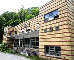 Algoma Coal and Coke Company Store |
April 17, 1992 (#92000323) |
County Route 17 37°25′10″N 81°25′35″W |
Algoma | |
| 2 | Ashland Company Store | 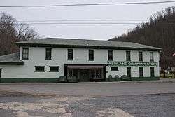 Ashland Company Store |
May 5, 2005 (#05000399) |
County Route 17 37°24′33″N 81°21′14″W |
Ashland | |
| 3 | Carter Coal Company Store | Carter Coal Company Store |
April 17, 1992 (#92000329) |
Junction of WV 16 and County Route 12/8 37°20′01″N 81°40′28″W |
Caretta | |
| 4 | Carter Coal Company Store | 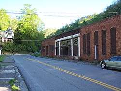 Carter Coal Company Store |
April 17, 1992 (#92000328) |
County Route 2 37°23′14″N 81°39′06″W |
Coalwood | Demolished March 29, 2008.[5] |
| 5 | Empire Coal Company Store | 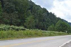 Empire Coal Company Store |
April 17, 1992 (#92000321) |
U.S. Route 52 37°24′43″N 81°28′28″W |
Landgraff | No longer extant.[6] |
| 6 | Houston Coal Company Store | 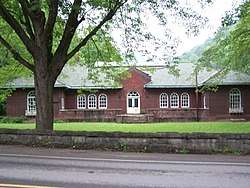 Houston Coal Company Store |
April 17, 1992 (#92000331) |
U.S. Route 52 37°25′48″N 81°30′32″W |
Carswell | |
| 7 | James Ellwood Jones House | 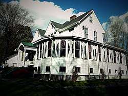 James Ellwood Jones House |
April 2, 1992 (#92000306) |
North of U.S. Route 52, east of Turkey Gap Branch 37°22′17″N 81°22′52″W |
Switchback | |
| 8 | John J. Lincoln House | John J. Lincoln House |
July 16, 1992 (#92000900) |
North of U.S. Route 52 37°23′07″N 81°24′46″W |
Elkhorn | |
| 9 | McDowell County Courthouse | 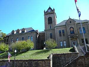 McDowell County Courthouse |
August 29, 1979 (#79003256) |
Wyoming St. 37°25′57″N 81°35′03″W |
Welch | |
| 10 | Page Coal and Coke Company Store | 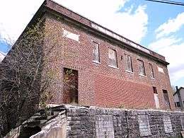 Page Coal and Coke Company Store |
April 17, 1992 (#92000325) |
WV 161 37°20′57″N 81°27′53″W |
Pageton | |
| 11 | Peerless Coal Company Store | 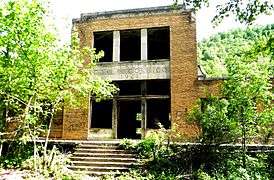 Peerless Coal Company Store |
April 17, 1992 (#92000322) |
South of U.S. Route 52 37°25′03″N 81°29′26″W |
Vivian | |
| 12 | Pocahontas Fuel Company Store |  Pocahontas Fuel Company Store |
April 17, 1992 (#92000324) |
U.S. Route 52 37°22′32″N 81°21′48″W |
Maybeury | Demolished sometime after March 2005.[7] |
| 13 | Pocahontas Fuel Company Store | April 17, 1992 (#92000330) |
U.S. Route 52 37°22′14″N 81°23′04″W |
Switchback | ||
| 14 | Pocahontas Fuel Company Store and Office Buildings | 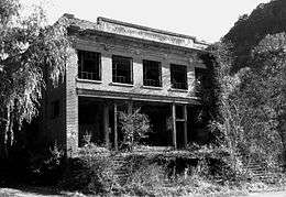 Pocahontas Fuel Company Store and Office Buildings |
April 17, 1992 (#92000326) |
County Route 8 37°17′28″N 81°25′25″W |
Jenkinjones | |
| 15 | U.S. Coal and Coke Company Store | 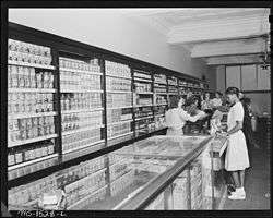 U.S. Coal and Coke Company Store |
April 17, 1992 (#92000327) |
County Route 13/2 37°21′05″N 81°32′51″W |
Ream | Demolished sometime between March 2004 and 2006.[7] |
| 16 | Welch Commercial Historic District | 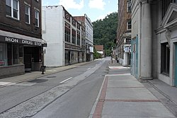 Welch Commercial Historic District |
April 2, 1992 (#92000305) |
Roughly bounded by Wyoming St., Elkhorn Creek and the Tug River 37°25′57″N 81°35′08″W |
Welch | Boundary increase approved December 14, 2018 |
| 17 | World War Memorial | 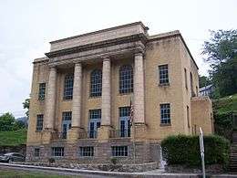 World War Memorial |
April 9, 1993 (#93000227) |
U.S. Route 52 37°25′31″N 81°30′24″W |
Kimball |
See also
| Wikimedia Commons has media related to National Register of Historic Places in McDowell County, West Virginia. |
References
- The latitude and longitude information provided in this table was derived originally from the National Register Information System, which has been found to be fairly accurate for about 99% of listings. Some locations in this table may have been corrected to current GPS standards.
- "National Register of Historic Places: Weekly List Actions". National Park Service, United States Department of the Interior. Retrieved on August 14, 2020.
- Numbers represent an ordering by significant words. Various colorings, defined here, differentiate National Historic Landmarks and historic districts from other NRHP buildings, structures, sites or objects.
- The eight-digit number below each date is the number assigned to each location in the National Register Information System database, which can be viewed by clicking the number.
- "Coalwood". Archived from the original on March 16, 2010. Retrieved March 16, 2010.
- "Aerial Photography of Empire Coal Company Store Site". Google Maps. Google. Retrieved April 27, 2010.
- Dellamea, Chris. "Flat Top Field - McDowell County". Coalfields of the Appalachian Mountains. Retrieved April 27, 2010.
| Topics | ||
|---|---|---|
| Lists by county |
| |
| Other lists | ||
| ||
Municipalities and communities of McDowell County, West Virginia, United States | ||
|---|---|---|
| Cities | Map of West Virginia highlighting McDowell County | |
| Towns | ||
| CDPs | ||
| Unincorporated communities |
| |
| Ghost town | ||
| Footnotes | ‡This populated place also has portions in an adjacent county or counties | |