National Register of Historic Places listings in Lewis County, West Virginia
This is a list of the National Register of Historic Places listings in Lewis County, West Virginia.
This is intended to be a complete list of the properties and districts on the National Register of Historic Places in Lewis County, West Virginia, United States. The locations of National Register properties and districts for which the latitude and longitude coordinates are included below, may be seen in a Google map.[1]
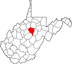
There are 12 properties and districts listed on the National Register in the county, 1 of which is a National Historic Landmark.
- This National Park Service list is complete through NPS recent listings posted August 14, 2020.[2]
Barbour - Berkeley - Boone - Braxton - Brooke - Cabell - Calhoun - Clay - Doddridge - Fayette - Gilmer - Grant - Greenbrier - Hampshire - Hancock - Hardy - Harrison - Jackson - Jefferson - Kanawha - Lewis - Lincoln - Logan - Marion - Marshall - Mason - McDowell - Mercer - Mineral - Mingo - Monongalia - Monroe - Morgan - Nicholas - Ohio - Pendleton - Pleasants - Pocahontas - Preston - Putnam - Raleigh - Randolph - Ritchie - Roane - Summers - Taylor - Tucker - Tyler - Upshur - Wayne - Webster - Wetzel - Wirt - Wood - Wyoming |
Current listings
| [3] | Name on the Register[4] | Image | Date listed[5] | Location | City or town | Description |
|---|---|---|---|---|---|---|
| 1 | Annamede | March 11, 1987 (#87000218) |
RD 1, Box 126, U.S. Route 19 38°52′35″N 80°26′35″W |
Walkersville | ||
| 2 | Jonathan M. Bennett House |  Jonathan M. Bennett House |
June 9, 1978 (#78002804) |
Court Ave. 39°02′11″N 80°27′55″W |
Weston | |
| 3 | Jackson's Mill | Jackson's Mill |
February 23, 1972 (#72001289) |
East of Jackson Mill on Route 1 39°05′46″N 80°27′59″W |
Weston | |
| 4 | Jackson's Mill State 4-H Camp Historic District |  Jackson's Mill State 4-H Camp Historic District |
February 4, 2005 (#04001598) |
160 Jackson Mill Rd. 39°05′55″N 80°28′12″W |
Weston | |
| 5 | May-Kraus Farm | March 22, 2006 (#06000175) |
3052 Crooked Run Rd. 39°01′22″N 80°37′46″W |
Alum Bridge | ||
| 6 | St. Bernard Church and Cemetery | 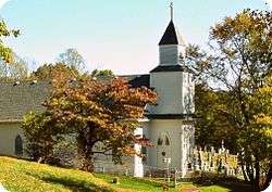 St. Bernard Church and Cemetery |
July 12, 1985 (#85001583) |
County Routes 20/6 and 17/2 38°59′35″N 80°35′34″W |
Camden | |
| 7 | Upper Glady School |  Upper Glady School |
March 20, 2002 (#02000252) |
County Route 52, 1.9 miles north of McCord Run Rd. 38°48′59″N 80°24′26″W |
Crawford | |
| 8 | Walkersville Covered Bridge |  Walkersville Covered Bridge |
June 4, 1981 (#81000603) |
On County Route 19/17 near U.S. Route 19 38°51′30″N 80°27′39″W |
Walkersville | |
| 9 | Weston Colored School |  Weston Colored School |
April 9, 1993 (#93000224) |
345 Center St. 39°02′23″N 80°27′53″W |
Weston | |
| 10 | Weston Downtown Historic District |  Weston Downtown Historic District |
September 28, 1985 (#85002468) |
Parts of Main, Center, and Court Aves., plus 2nd and 3rd Sts. 39°02′13″N 80°28′05″W |
Weston | |
| 11 | Weston Downtown Residential Historic District |  Weston Downtown Residential Historic District |
February 2, 2005 (#04001596) |
Portions of Main, Center, and Court Aves, plus E. 1st, E. 3rd, E. 4th, E. 5th, and E. 6th Sts. 39°02′32″N 80°27′47″W |
Weston | |
| 12 | Weston State Hospital |  Weston State Hospital |
April 19, 1978 (#78002805) |
River St. 39°02′18″N 80°28′16″W |
Weston |
See also
| Wikimedia Commons has media related to National Register of Historic Places in Lewis County, West Virginia. |
References
- The latitude and longitude information provided in this table was derived originally from the National Register Information System, which has been found to be fairly accurate for about 99% of listings. Some locations in this table may have been corrected to current GPS standards.
- "National Register of Historic Places: Weekly List Actions". National Park Service, United States Department of the Interior. Retrieved on August 14, 2020.
- Numbers represent an ordering by significant words. Various colorings, defined here, differentiate National Historic Landmarks and historic districts from other NRHP buildings, structures, sites or objects.
- "National Register Information System". National Register of Historic Places. National Park Service. April 24, 2008.
- The eight-digit number below each date is the number assigned to each location in the National Register Information System database, which can be viewed by clicking the number.
| Topics | ||
|---|---|---|
| Lists by county |
| |
| Other lists | ||
| ||
Municipalities and communities of Lewis County, West Virginia, United States | ||
|---|---|---|
| City | Lewis County map | |
| Town | ||
| Unincorporated communities |
| |
| Footnotes | ‡This populated place also has portions in an adjacent county or counties | |