National Register of Historic Places listings in Great Smoky Mountains National Park
This is a list of the National Register of Historic Places listings in Great Smoky Mountains National Park.
This is intended to be a complete list of the properties and districts on the National Register of Historic Places in Great Smoky Mountains National Park, North Carolina and Tennessee, United States. The locations of National Register properties and districts for which the latitude and longitude coordinates are included below, may be seen in a map.[1]
There are 19 properties and districts listed on the National Register in the park.
- This National Park Service list is complete through NPS recent listings posted August 14, 2020.[2]
Current listings
| [3] | Name on the Register | Image | Date listed[4] | Location | City or town | Description |
|---|---|---|---|---|---|---|
| 1 | Mayna Treanor Avent Studio | 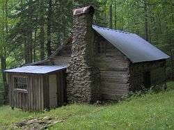 Mayna Treanor Avent Studio |
February 7, 1994 (#93001575) |
Jake's Creek Trail, 1.0 mile south of Elkton 35°38′21″N 83°35′15″W |
Elkmont | |
| 2 | Cades Cove Historic District | 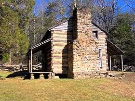 Cades Cove Historic District |
July 13, 1977 (#77000111) |
10 miles southwest of Townsend in Great Smoky Mountains National Park 35°35′13″N 83°48′54″W |
Townsend | |
| 3 | Clingmans Dome Observation Tower | 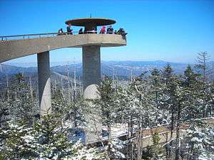 Clingmans Dome Observation Tower |
August 15, 2012 (#12000515) |
Terminus of Clingmans Dome Rd. 35°33′46″N 83°29′55″W |
Bryson City | |
| 4 | Alex Cole Cabin | 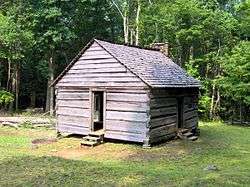 Alex Cole Cabin |
January 2, 1976 (#76000165) |
5 miles south of Gatlinburg off U.S. Route 441 in Great Smoky Mountains National Park 35°39′59″N 83°31′22″W |
Gatlinburg | |
| 5 | Elkmont Historic District, Great Smoky Mountains NP | 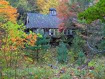 Elkmont Historic District, Great Smoky Mountains NP |
March 22, 1994 (#94000166) |
Off State Route 72 southwest of Gatlinburg 35°39′20″N 83°35′04″W |
Gatlinburg | |
| 6 | Hall Cabin |  Hall Cabin |
January 30, 1976 (#76000162) |
15 mi. NE of Fontana in Great Smoky Mountains National Park 35°31′12″N 83°40′46″W |
Fontana | |
| 7 | King-Walker Place | 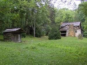 King-Walker Place |
March 16, 1976 (#76000169) |
West of Gatlinburg off State Route 73 in Great Smoky Mountains National Park 35°41′39″N 83°37′45″W |
Gatlinburg | |
| 8 | Little Greenbrier School-Church | 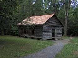 Little Greenbrier School-Church |
January 11, 1976 (#76000168) |
About 9 miles west of Gatlinburg off State Route 73 in Great Smoky Mountains National Park 35°41′01″N 83°38′17″W |
Gatlinburg | |
| 9 | Look Rock Observation Tower | 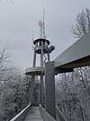 Look Rock Observation Tower |
October 12, 2017 (#100001750) |
Foothills Pkwy. W. 35°37′57″N 83°56′35″W |
Walland vicinity | |
| 10 | Tyson McCarter Place | 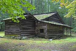 Tyson McCarter Place |
March 16, 1976 (#76000204) |
10 miles east of Gatlinburg on State Route 73 in Great Smoky Mountains National Park 35°46′N 83°18′W |
Gatlinburg | |
| 11 | Messer Barn | 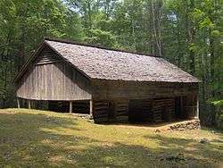 Messer Barn |
January 1, 1976 (#76000166) |
Southeast of Gatlinburg near Greenbrier Cove in Great Smoky Mountains National Park 35°41′13″N 83°23′54″W |
Gatlinburg | |
| 12 | Mingus Mill | 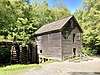 Mingus Mill |
November 29, 2016 (#16000808) |
Newfound Gap Rd., Great Smoky Mountains National Park 35°31′12″N 83°18′35″W |
Cherokee | |
| 13 | Mount Cammerer Fire Lookout | 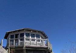 Mount Cammerer Fire Lookout |
June 12, 2019 (#100004091) |
Great Smoky Mountains National Park (GRSM) - end of Mount Cammerer 35°45′49″N 83°09′41″W |
Cosby | |
| 14 | Bud Ogle Farm | 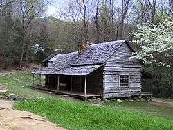 Bud Ogle Farm |
November 23, 1977 (#77000158) |
3 miles southeast of Gatlinburg 35°40′50″N 83°29′28″W |
Gatlinburg | |
| 15 | Oconaluftee Archeological District | February 19, 1982 (#82001715) |
Address Restricted |
Cherokee | ||
| 16 | Oconaluftee Baptist Church | 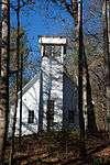 Oconaluftee Baptist Church |
January 1, 1976 (#76000163) |
6 mi. N of Cherokee on U.S. 441 in Great Smoky Mountains National Park 35°33′13″N 83°18′31″W |
Cherokee | |
| 17 | Oconaluftee Ranger Station | %2C_Cherokee%2C_NC.jpg) Oconaluftee Ranger Station |
November 29, 2016 (#16000809) |
Newfound Gap Rd., Great Smoky Mountains National Park 35°30′47″N 83°18′23″W |
Cherokee | |
| 18 | John Ownby Cabin | 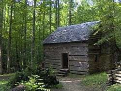 John Ownby Cabin |
January 1, 1976 (#76000167) |
3 miles south of Gatlinburg off State Route 73 in Great Smoky Mountains National Park 35°41′22″N 83°32′50″W |
Gatlinburg | |
| 19 | Roaring Fork Historic District | 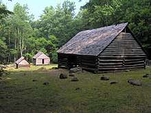 Roaring Fork Historic District |
March 16, 1976 (#76000170) |
5 miles southeast of Gatlinburg off State Route 73 in Great Smoky Mountains National Park 35°41′54″N 83°28′04″W |
Gatlinburg |
gollark: ++choose 1000 esobot macron "V O I D"
gollark: It has three "nodes", two actual nodes.
gollark: good.
gollark: > GIF
gollark: For apiopurposes.
See also
- National Register of Historic Places listings in Sevier County, Tennessee
- National Register of Historic Places listings in Blount County, Tennessee
- National Register of Historic Places listings in Cocke County, Tennessee
- National Register of Historic Places listings in Swain County, North Carolina
- National Register of Historic Places listings in Tennessee
- National Register of Historic Places listings in North Carolina
References
- The latitude and longitude information provided in this table was derived originally from the National Register Information System, which has been found to be fairly accurate for about 99% of listings. Some locations in this table may have been corrected to current GPS standards.
- "National Register of Historic Places: Weekly List Actions". National Park Service, United States Department of the Interior. Retrieved on August 14, 2020.
- Numbers represent an ordering by significant words. Various colorings, defined here, differentiate National Historic Landmarks and historic districts from other NRHP buildings, structures, sites or objects.
- The eight-digit number below each date is the number assigned to each location in the National Register Information System database, which can be viewed by clicking the number.
| Topics | |
|---|---|
| Lists by state |
|
| Lists by insular areas | |
| Lists by associated state | |
| Other areas | |
| Related | |
| |
| Wikimedia Commons has media related to National Register of Historic Places in Great Smoky Mountains National Park. |
This article is issued from Wikipedia. The text is licensed under Creative Commons - Attribution - Sharealike. Additional terms may apply for the media files.