National Register of Historic Places listings in Central Falls, Rhode Island
This is a list of Registered Historic Places in Central Falls, Rhode Island.
Bristol | Kent | Newport | Providence | Washington |
- This National Park Service list is complete through NPS recent listings posted August 14, 2020.[1]
| [2] | Name on the Register[3] | Image | Date listed[4] | Location | City or town | Description |
|---|---|---|---|---|---|---|
| 1 | Central Falls Congregational Church | 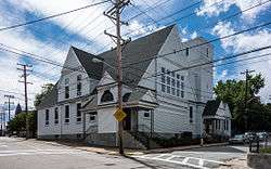 Central Falls Congregational Church |
July 12, 1976 (#76000042) |
376 High St. 41°53′05″N 71°23′04″W |
Central Falls | |
| 2 | Central Falls Mill Historic District | 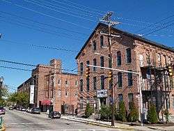 Central Falls Mill Historic District |
July 2, 1976 (#76000007) |
Between Roosevelt Avenue and the Blackstone River 41°53′11″N 71°22′55″W |
Central Falls | |
| 3 | Central Street School | 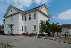 Central Street School |
April 6, 1979 (#79000004) |
379 Central St. 41°53′04″N 71°23′38″W |
Central Falls | |
| 4 | Samuel B. Conant House | 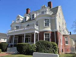 Samuel B. Conant House |
April 6, 1979 (#79000005) |
104 Clay St. 41°52′59″N 71°23′25″W |
Central Falls | |
| 5 | Conant Thread-Coats & Clark Mill Complex District | 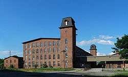 Conant Thread-Coats & Clark Mill Complex District |
November 18, 1983 (#83003809) |
Roughly bounded by Lonsdale Avenue, Rand and Pine Streets. 41°52′51″N 71°23′53″W |
Central Falls | Extends into Pawtucket |
| 6 | David G. Fales House | 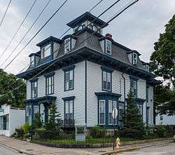 David G. Fales House |
April 6, 1979 (#79000006) |
476 High St. 41°53′10″N 71°23′05″W |
Central Falls | |
| 7 | Benjamin F. Greene House | 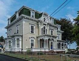 Benjamin F. Greene House |
April 6, 1979 (#79000007) |
85 Cross St. 41°53′08″N 71°23′11″W |
Central Falls | |
| 8 | Holy Trinity Church Complex | 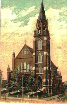 Holy Trinity Church Complex |
January 3, 1978 (#78000073) |
134 Fuller Ave. 41°53′19″N 71°23′47″W |
Central Falls | Church demolished; only the parish house is extant. |
| 9 | Jenks Park & Cogswell Tower | 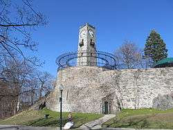 Jenks Park & Cogswell Tower |
April 6, 1979 (#79000057) |
Adjoining 580 Broad St. 41°53′15″N 71°23′21″W |
Central Falls | |
| 10 | St. Matthew's Church | 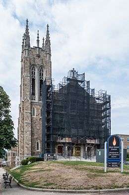 St. Matthew's Church |
April 6, 1979 (#79000008) |
Dexter and W. Hunt Sts. 41°53′21″N 71°24′07″W |
Central Falls | |
| 11 | South Central Falls Historic District |  South Central Falls Historic District |
January 31, 1991 (#91000025) |
Roughly bounded by the Central Falls-Pawtucket boundary and Rand, Summit, Dexter and Broad Sts. 41°53′04″N 71°23′28″W |
Central Falls | |
| 12 | Valley Falls Mill | 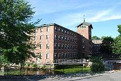 Valley Falls Mill |
April 26, 1978 (#78000012) |
1359 and 1361-63 Broad St. 41°53′55″N 71°23′20″W |
Central Falls | Boundary increase December 18, 1978. |
See also
References
- "National Register of Historic Places: Weekly List Actions". National Park Service, United States Department of the Interior. Retrieved on August 14, 2020.
- Numbers represent an ordering by significant words. Various colorings, defined here, differentiate National Historic Landmarks and historic districts from other NRHP buildings, structures, sites or objects.
- "National Register Information System". National Register of Historic Places. National Park Service. March 13, 2009.
- The eight-digit number below each date is the number assigned to each location in the National Register Information System database, which can be viewed by clicking the number.
| Topics | _(extra_close)_(US48).svg.png) | ||||||||||
|---|---|---|---|---|---|---|---|---|---|---|---|
| Lists by county | |||||||||||
| Lists by city |
| ||||||||||
| |||||||||||
This article is issued from Wikipedia. The text is licensed under Creative Commons - Attribution - Sharealike. Additional terms may apply for the media files.