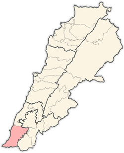
Naqoura
Naqoura (Arabic: الناقورة, Enn Nâqoura, Naqoura, An Nāqūrah) is a small city in southern Lebanon. Since March 23, 1978, the United Nations Interim Force in Lebanon (UNIFIL) has been headquartered in Naqoura.
Naqoura الناقورة | |
|---|---|
 Naqoura Location within Lebanon | |
| Coordinates: 33°07′12″N 35°08′03″E | |
| Grid position | 163/281 PAL |
| Country | |
| Governorate | South Governorate |
| District | Tyre District |
| Highest elevation | 60 m (200 ft) |
| Time zone | +2 |
| • Summer (DST) | +3 |
Name
According to E. H. Palmer, the name means "the horn" or "the trumpet". This name rises apparently from a misconception on the part of the Arab-speaking inhabitants, as the name, [..] Tyre means in Arabic a horn or trumpet; therefore Ras Sur (the headland or ladder of Tyre') is rendered by Nakura, the synonym for Sur. The word is also connected with [..] to peck or perforate."[1]
History
.jpg)
In 1875, during the late Ottoman era, Victor Guérin described it: "The village stands upon a hill, on the south of which is a deep way, through which flows a spring called 'Ain Nakurah, which waters plantations of fig-trees and olives mixed with palms. The village contains 400 Metawileh. The houses are modern, but some of the materials appear ancient by their regularity and dimensions. There must, therefore, have been an older village here, the name of which was probably similar, if not identical."[2] According to Guérin, the place is associated with the historic Ladder of the Tyrians (Scala Tyriorum).[3]
In 1881, the PEF's Survey of Western Palestine (SWP) described it: "A village, built of stone, containing about 250 Moslems, situated on low hills by sea-coast. Gardens of olives, palms, pomegranates, figs, and arable land ; brushwood to the east. Two springs with plentiful supply of water."[4]
References
Bibliography
- Conder, C.R.; Kitchener, H.H. (1881). The Survey of Western Palestine: Memoirs of the Topography, Orography, Hydrography, and Archaeology. 1. London: Committee of the Palestine Exploration Fund.
- Guérin, V. (1880). Description Géographique Historique et Archéologique de la Palestine (in French). 3: Galilee, pt. 2. Paris: L'Imprimerie Nationale.
- Palmer, E.H. (1881). The Survey of Western Palestine: Arabic and English Name Lists Collected During the Survey by Lieutenants Conder and Kitchener, R. E. Transliterated and Explained by E.H. Palmer. Committee of the Palestine Exploration Fund.
External links
- Naqoura, Localiban
- Survey of Western Palestine, Map 3: IAA, Wikimedia commons
