Mystic Lakes (Boston)
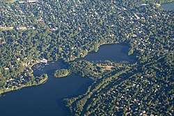
The Mystic Lakes, consisting of Upper Mystic Lake and Lower Mystic Lake, are closely linked bodies of water in the northwestern suburbs of Boston, Massachusetts.
| Mystic Lakes | |
|---|---|
 Aerial photograph of Upper Mystic Lake | |
| Location | Arlington, Medford, and Winchester, Massachusetts |
| Coordinates | 42°25′54″N 71°8′54″W[1] |
| Type | meromictic |
| Primary inflows | Aberjona River |
| Primary outflows | Mystic River |
| Basin countries | United States |
.jpg)
The lakes lie at an elevation of 1 meter above sea level, within the towns of Winchester, Arlington, and Medford, Massachusetts. Upper Mystic Lake is fed by the Aberjona River, and drains south, over the Mystic Dam, into Lower Mystic Lake, which in turn empties into the Mystic River and then Boston Harbor.
Description
Lower Mystic Lake is a meromictic lake, which means that the lake has a deep layer of water that rarely, if ever, mixes with its top waters. As a consequence, the sediments at the bottom of Lower Mystic Lake accumulate in annual layers (or varves) that have been nearly undisturbed for a thousand years. Such varves in meromictic lakes preserve an historical record somewhat like tree rings do. In the case of Lower Mystic Lake, the varves have been used by Mark Besonen and his collaborators to study the historical incidence of hurricanes.[2][3][4][5]
Although the Mystic Lakes are popular for swimming, sailing, and fishing, the Upper Mystic Lake suffers from contamination by arsenic and other heavy metals from the Aberjona River.[6][7][8]
The eastern shore of the lakes is part of the Mystic River Reservation managed by the Massachusetts Department of Conservation and Recreation.
The lakes were previously part of the drinking water supply for Charlestown and later Boston (see Massachusetts Water Resources Authority).[9]
History
In the 1600s, the Squaw Sachem of Mistick, who deeded much of the land in Greater Boston to settlers, resided near the Mystics Lakes.
References
- U.S. Geological Survey Geographic Names Information System: Mystic Lakes
- Besonen, Mark R.; Bradley, Raymond S.; Mudelsee, Manfred; Abbott, Mark B.; Francus, Pierre (2008). "A 1,000-year, annually-resolved record of hurricane activity from Boston, Massachusetts". Geophysical Research Letters. 35 (14): L14705. Bibcode:2008GeoRL..3514705B. doi:10.1029/2008GL033950.
- Anonymous (2005). "Mysteries in the Muck", UMass Magazine Online, Fall 2005 issue. Online version retrieved May 1, 2008.
- Besonen, Mark R., Abbott, Mark B., Francus, Pierre and Bradley, Raymond S. (2006). "A 1,000-Year High-Resolution Hurricane Activity Record for the Boston Area", Gulf Coast Association of Geological Societies 2006 Convention, September 25–27, 2006, Lafayette, Louisiana.
- Besonen, Mark R. (2006). A 1,000 year high-resolution hurricane history for the Boston area based on the varved sedimentary record from the Lower Mystic Lake (Medford/Arlington, Massachusetts), University of Massachusetts Amherst doctoral dissertation.
- Senn, D. B.; Hemond, H. F. (2002). "Nitrate Controls on Iron and Arsenic in an Urban Lake". Science. 296 (5577): 2373–2376. Bibcode:2002Sci...296.2373S. doi:10.1126/science.1072402. PMID 12089437.
- Inhof, Christina J. (1998). "Research Brief 32: Understanding the Physical Processes Involved in Metal Transport in the Upper Mystic Lake", Release Date: 28 October 1998, Superfund Basic Research Program.
- Rauch, S.; Hermond, H. F.; Ravizza, G.; Morrison, G. M. (2003). "Chronology of platinum accumulation in an urban lake". Journal de Physique IV (Proceedings). 107 (1): 1123–1126. Bibcode:2003JPhy4.107.1123R. doi:10.1051/jp4:20030498.
- "Metropolitan Boston's Water System History". Massachusetts Water Resources Authority. July 2, 2013. Retrieved 2013-08-02.