Muskegon River
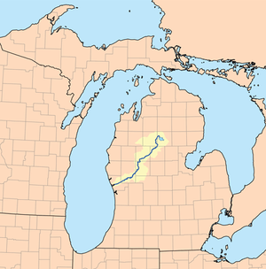
Muskegon River is a river in the western portion of the lower peninsula of the U.S. state of Michigan. The river has its headwaters in Houghton Lake in Roscommon County, flowing out of the North Bay into neighboring Missaukee County. From there it flows mostly southwest to Muskegon, Michigan, where it empties into Muskegon Lake. Muskegon Lake is connected to Lake Michigan via a mile-long channel. The river has several major branches, such as the Hersey River, Cedar Creek and Little Muskegon River. The main stream is 216 miles (348 km) long[1] and drains an area of 2,350 square miles (6,100 km2).[2] In September 2002 an often cited article, National Geographic raised concerns about a controversial deal made with Nestle Waters North America giving them permission "to bottle up to 210 million gallons (about 800 million liters) a year from an aquifer north of Grand Rapids, Michigan that recharges the Muskegon River." [3]
| Muskegon River | |
|---|---|
Muskegon River near Newaygo, MI in September 2012 | |
 Map of the Muskegon River | |
| Location | |
| Country | United States |
| State | Michigan |
| Cities | Evart, Big Rapids, Croton, Newaygo, Muskegon |
| Physical characteristics | |
| Source | Houghton Lake |
| • location | MI |
| • coordinates | 44°23′58″N 84°47′27″W |
| Mouth | Muskegon Lake |
• location | Muskegon, MI |
• coordinates | 43°15′41″N 86°14′53″W |
| Length | 216 mi (348 km) |
| Basin size | 2,350 sq mi (6,100 km2) |
| Discharge | |
| • location | Muskegon, MI |
History
Like many of its neighboring streams, the Muskegon was one of the favored logging rivers during the boom years of the 1880s-1890s, and a keen eye can still pick out remnants of stray logs left over from the spring logging runs which are embedded on the river bottom.
Winfield Scott Gerrish is credited with revolutionizing lumbering in Michigan by building a seven-mile-long logging railroad from Lake George to the Muskegon River.[4] However, there were several Michigan logging railroads in operation in the 1850s including the seven-mile-long Blendon Lumber Company railroad in Ottawa County which was the first in the state to employ a steam locomotive in May 1857. [5]
Wildlife
There is abundant wildlife, including otters, waterfowl, deer and eagles and, although development has been creeping in, the upper reaches are still fairly remote and natural with much of the surrounding land composed of state-owned tracts.
Recreation
- In recent years, the river has gained a certain measure of fame as a recreational fishery, boasting large migratory steelhead, brown trout and planted Chinook Salmon.
- People have also taken quite a liking to paddling down the river. It is Michigan's second largest river only to the Grand River. It is surprisingly quite slow, making it perfect for beginners learning in either a kayak or canoe.[6]
- Being such a peaceful river, it promises ample opportunities for viewing wildlife. This factor attracts tourists from across the state, and the world.
Camping is another popular activity around the river with there being several shoreline parks, and campgrounds. There are also various inns and cabins down the river that can provide a night, week's or a month's accommodations. Hunting is popular in the forests near by on public hunting land.
Dams
The three major dams of the Muskegon River (Rogers, Hardy and Croton) generate about 45,600 kilowatts, with about 30,000 of that from Hardy Dam. That is enough electricity to serve a community of nearly 23,000.[7] The smaller Reedsburg Dam is near the source of the Muskegon River.
| Name | Height | Purpose(s) | Capacity (MW) | Year | Owner name | Reservoir name | Coordinates | Comments |
|---|---|---|---|---|---|---|---|---|
| Croton | 40 ft (12.2 m) | Hydroelectric | 8.85 | 1907 | Consumers Energy | Croton Dam Pond | 43.43714°N 85.66382°W | |
| Hardy | 106 ft (32.3 m) | Hydroelectric | 30 | 1931 | Consumers Energy | Hardy Dam Pond | 43.48656°N 85.6296°W | |
| Reedsburg | N/A | Flood control | N/A | 1940 | Michigan DNR | Dead Stream Flooding | 44.35612°N 84.8593°W | |
| Rogers | 43 ft (13.1 m) | Hydroelectric | 6.75 | 1906 | Consumers Energy | Rogers Dam Pond | 43.61320°N 85.47894°W | |
| Total | 45.6 | |||||||
References
- U.S. Geological Survey. National Hydrography Dataset high-resolution flowline data. The National Map, accessed November 21, 2011
- O'Neal, Richard (July 1997), Muskegon River Watershed Assessment (PDF), Michigan Department of Natural Resources, retrieved 30 July 2011
- Mitchell, John G. (September 2002). "Down the Drain: The Incredible Shrinking Great Lakes". National Geographic. pp. 34–51.
- "The Forests of Michigan - page 143". University of Michigan Press, 2003. Retrieved 5 March 2016.
- Bajema, Carl Jay (April 1991). "The First Logging Railroads in the Great Lakes Region" (PDF). The First Logging Railroads in the Great Lakes Region. Oxford University Press on behalf of Forest History Society and American Society for Environmental History. Retrieved Sep 25, 2010.
- Hillstrom, Kevin, and Laurie Hillstrom. Paddling Michigan. Guilford: Falcon Publishing, 2001. 98-100.
- "Muskegon River". Consumers Energy website. Retrieved July 30, 2011. External link in
|work=(help)
| Wikimedia Commons has media related to Muskegon River. |