Murrisk
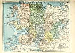
Murrisk (Irish: Muraisc) is a village in County Mayo, Ireland, on the south side of Clew Bay, about 8 km west of Westport and 4 km east of Lecanvey.
Murrisk Muraisc | |
|---|---|
Village and district | |
 Murrisk Location in Ireland | |
| Coordinates: 53°46′42″N 9°37′53″W | |
| Country | Ireland |
| Province | Connacht |
| County | County Mayo |
| Elevation | 70 m (230 ft) |
| Population (2016)[1] | 266 (approx) |
| (Reflects the small area which partially surrounds Murrisk) | |
| Time zone | UTC+0 (WET) |
| • Summer (DST) | UTC-1 (IST (WEST)) |
| Irish Grid Reference | L925821 |
Murrisk lies at the foot of Croagh Patrick and is the starting-point for pilgrims who visit the mountain. Every year, on the last Sunday of July, thousands of people converge on the village to make the pilgrimage. There is a small interpretative centre in the village, which focuses on Croagh Patrick.
The name is also used for the entire district south to the fjord of Killary Harbour. This barony runs from Westport and also includes Louisburgh and Lecanvey; there is also at least one abandoned village, Uggool.
Transport
Road
Murrisk is located on the R335 regional road.
Bus Éireann local route 450 Louisburgh-Lecanvey-Murrisk-Westport provides two to three journeys in each direction daily except Sundays. On Thursdays the route extends west to Killadoon.[2]
Rail
The nearest train station is Westport railway station approximately 11 kilometres (6.8 mi) distant.
Places of interest

The ruined Murrisk Abbey just to the seaward side of the village was an Augustinian abbey founded in 1457 by the O'Malley family. It was suppressed in the Reformation, but survived for some time.
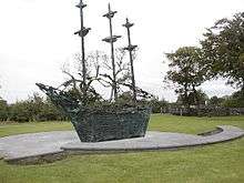
Murrisk is also the site of Ireland's National Famine Memorial, designed by Irish artist John Behan, which abstractly resembles a coffin ship filled with dying people. The monument was unveiled in July 1997 by President Mary Robinson.[3]
Religion
Murrisk is part of both the Roman Catholic and Church of Ireland parishes of Oughaval. Catholic records consist of marriages (from 1825) and baptisms (from 1845) and Church of Ireland records of baptisms, marriages and burials (all from 1802). These records are held at the South Mayo Family Research Centre in Ballinrobe which is 32 km southeast of Westport.
See also

References
- "Census 2016 Sapmap Area: Settlements Murrisk SA: 157063003/157063004/157063005". Central Statistics Office (Ireland). Retrieved 16 December 2019.
- "Archived copy" (PDF). Archived from the original (PDF) on 25 October 2012. Retrieved 11 March 2015.CS1 maint: archived copy as title (link)
- http://www.mayo-ireland.ie/Mayo/Towns/Murrisk/Index.htm
