Mua District
Mua (also spelled Mu'a, Uvean for "first") is one of the 5 districts of Wallis and Futuna, located in Wallis Island, in the Pacific Ocean. It is part of the Chiefdom of Uvea.
Mua Mu'a | |
|---|---|
District | |
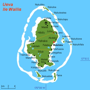 Map of Wallis Island showing the 3 districts: Mua is located in south | |
| Coordinates: 13°20′25″S 176°11′30″W | |
| Country | |
| Territory | |
| Island | Wallis |
| Chiefdom | Uvea |
| Capital | Mala'efo'ou |
| Area | |
| • Total | 26,3 km2 (102 sq mi) |
| Population (2018) | |
| • Total | 2,976 |
| Time zone | UTC+12 |
| No. of municipalities | 10 |
Geography
Located in the southern side of the island, Mua borders with the districts of Hahake. Mala'efo'ou (formerly named Mu'a) is the administrative seat.
The district is divided into 10 municipal villages:[1]
| Village | Population |
|---|---|
| Utufua | 602 |
| Halalo | 471 |
| Vaimalau | 371 |
| Lavegahau | 330 |
| Teesi | 216 |
| Malaefoou | 171 |
| Gahi | 249 |
| Tepa | 270 |
| Haatofo | 197 |
| Kolopopo | 99 |
gollark: potatOS.asm
gollark: gobson.s
gollark: One you missed is that the variable the keycode will be saved in is `k`, but the conditional checks `key`.
gollark: Fun exercise: See how many problems you can spot.
gollark: There is nothing sensible about this code.
See also
References
- "Population municipale des villages des îles Wallis et Futuna (recensement 2018)". INSEE. Retrieved 21 February 2020.
External links
- Google (4 September 2013). "Mua District" (Map). Google Maps. Google. Retrieved 4 September 2013.
Wallis and Futuna articles | |||
|---|---|---|---|
| |||
| Islands |  | ||
| Chiefdoms | |||
| Geography |
| ||
| Politics |
| ||
| Economy |
| ||
| Culture |
| ||
| |||
This article is issued from Wikipedia. The text is licensed under Creative Commons - Attribution - Sharealike. Additional terms may apply for the media files.