Hahake District
Hakake (Uvean for "East") is one of the 5 districts of Wallis and Futuna, located in Wallis Island, in the Pacific Ocean. It is part of the Chiefdom of Uvea.
Hahake | |
|---|---|
District | |
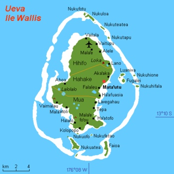 Map of Wallis Island showing the 3 districts: Hahake is located in the middle | |
| Coordinates: 13°17′S 176°11′W | |
| Country | |
| Territory | |
| Island | Wallis |
| Chiefdom | Uvea |
| Capital | Mata-Utu |
| Area | |
| • Total | 27.8 km2 (10.7 sq mi) |
| Population (2018) | |
| • Total | 3,415 |
| Time zone | UTC+12 |
| No. of municipalities | 6 |
Geography
Located in the middle of the island, Hahake borders with the districts of Hihifo and Mua. Mata-Utu (or Matāʻutu) is the capital of the district, and of the Wallis and Futuna Territory as a whole.
The district is divided into 6 municipal villages:[1]
| Village | Population |
|---|---|
| Mata'utu | 1,029 |
| Liku | 605 |
| Falaleu | 572 |
| Aka'aka | 474 |
| Ahoa | 436 |
| Haafuasia | 299 |
gollark: I have actually fixed all the ones I know of now, though!
gollark: Also, there are exploits in the wild.
gollark: If the `uninstall` command is too complex for you, that is your fault.
gollark: You can uninstall it easily.
gollark: Oh, and user accounts. That could be fun.
References
- "Population municipale des villages des îles Wallis et Futuna (recensement 2018)". INSEE. Retrieved 21 February 2020.
External links
| Wikimedia Commons has media related to Hahake District. |
- Map showing the location of Mata-Utu
- Picture of the lagoon of Mata-Utu (Archived 2009-10-31)
- Google (4 September 2013). "Hahake District" (Map). Google Maps. Google. Retrieved 4 September 2013.
Wallis and Futuna articles | |||
|---|---|---|---|
| |||
| Islands |  | ||
| Chiefdoms | |||
| Geography |
| ||
| Politics |
| ||
| Economy |
| ||
| Culture |
| ||
| |||
This article is issued from Wikipedia. The text is licensed under Creative Commons - Attribution - Sharealike. Additional terms may apply for the media files.