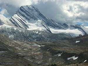
Mount Sir Douglas
Mount Sir Douglas is located on the border of Alberta and British Columbia on the Continental Divide. It is Alberta's 18th highest peak, and 28th prominence mountain as well as British Columbia's 28th highest peak. It was named in 1916 after Field Marshal Sir Douglas Haig.[1][2]
| Mount Sir Douglas | |
|---|---|
 | |
| Highest point | |
| Elevation | 3,411 m (11,191 ft) [1] |
| Prominence | 1,110 m (3,640 ft) [1] |
| Coordinates | 50°43′20″N 115°20′20″W [1] |
| Geography | |
 Mount Sir Douglas | |
| Parent range | Canadian Rockies |
| Topo map | NTS 82J/11 |
| Climbing | |
| First ascent | 1919 J.W.A. Hickson and Edward Feuz Jr[2] |
| Easiest route | North-West Face III |
Geology
Mount Sir Douglas is composed of sedimentary rock laid down during the Precambrian to Jurassic periods. Formed in shallow seas, this sedimentary rock was pushed east and over the top of younger rock during the Laramide orogeny.[3]
Climate
Based on the Köppen climate classification, Mount Sir Douglas is located in a subarctic climate with cold, snowy winters, and mild summers.[4] Temperatures can drop below −20 C with wind chill factors below −30 C.
gollark: Horse = hash table with many collisions
gollark: Horse = Mooosey-Andrew set theory
gollark: Horse = Norse
gollark: Horse = horsew
gollark: Horse = cryoapioform
See also
- List of peaks on the British Columbia – Alberta border
- Mountains of Alberta
- Mountains of British Columbia
References
- "Mount Sir Douglas". Bivouac.com. Retrieved 2010-02-14.
- "Mount Sir Douglas". PeakFinder.com. Retrieved 2019-08-20.
- Gadd, Ben (2008). "Geology of the Rocky Mountains and Columbias". Cite journal requires
|journal=(help) - Peel, M. C.; Finlayson, B. L. & McMahon, T. A. (2007). "Updated world map of the Köppen−Geiger climate classification". Hydrol. Earth Syst. Sci. 11: 1633–1644. ISSN 1027-5606.
External links
- Mount Sir Douglas weather site: Mountain Forecast
This article is issued from Wikipedia. The text is licensed under Creative Commons - Attribution - Sharealike. Additional terms may apply for the media files.