Mount Laussedat
Mount Laussedat is a 3,052-meter (10,013-foot) mountain summit located in the Canadian Rockies of British Columbia, Canada. It is the highest point in the Southwest Central Park Ranges.[3] The mountain is situated 29 km (18 mi) north of Golden in the Blaeberry Valley. The first ascent of the mountain was made in 1906 by C. B. Sissons, Arthur Oliver Wheeler, and M. Wheeler.[4] The peak was named in 1911 by surveyor Arthur Oliver Wheeler for Aimé Laussedat (1819-1907), a French military officer whose pioneering photographic surveying techniques were used by Wheeler and Canada's Interprovincial Boundary Surveyors.[4][5] The mountain's name was officially adopted March 31, 1924, when approved by the Geographical Names Board of Canada.[2]
| Mount Laussedat | |
|---|---|
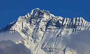 Mount Laussedat, south aspect | |
| Highest point | |
| Elevation | 3,052 m (10,013 ft) [1] |
| Prominence | 986 m (3,235 ft) [1] |
| Parent peak | Mount Mummery (3331 m) |
| Coordinates | 51°34′20″N 116°57′20″W [2] |
| Geography | |
 Mount Laussedat Location in British Columbia  Mount Laussedat Mount Laussedat (Canada) | |
| Location | British Columbia, Canada |
| Parent range | Southwest Central Park Ranges[3] Canadian Rockies |
| Topo map | NTS 82N10 |
| Geology | |
| Age of rock | Cambrian |
| Type of rock | Sedimentary |
| Climbing | |
| First ascent | 1906 |
Climate
Based on the Köppen climate classification, Mount Laussedat is located in a subarctic climate with cold, snowy winters, and mild summers.[6] Temperatures can drop below −20 °C with wind chill factors below −30 °C. Precipitation runoff from the mountain drains north into Waitabit Creek, or south into the Blaeberry River, which are both tributaries of the Columbia River.
References
- "Mount Laussedat". Bivouac.com. Retrieved 2020-01-07.
- "Mount Laussedat". Geographical Names Data Base. Natural Resources Canada. Retrieved 2020-01-07.
- "Mount Laussedat". Peakbagger.com. Retrieved 2020-01-07.
- "Mount Laussedat". PeakFinder.com. Retrieved 2020-01-07.
- "Mount Laussedat". BC Geographical Names.
- Peel, M. C.; Finlayson, B. L. & McMahon, T. A. (2007). "Updated world map of the Köppen−Geiger climate classification". Hydrol. Earth Syst. Sci. 11: 1633–1644. ISSN 1027-5606.
External links
- Weather: Mount Laussedat
- Wikipédia Français: Aimé Laussedat
- Laussedat, Aimé: Encyclopedia.com