Mount Mummery
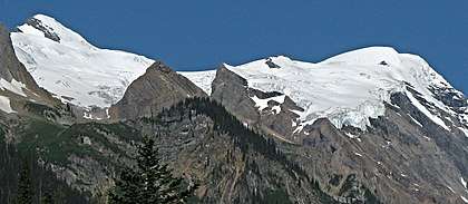
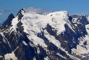
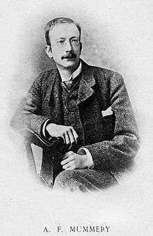
Mount Mummery is a 3,331-meter (10,928-foot) glaciated double summit mountain located in the Canadian Rockies of British Columbia, Canada. It is the highest point in the Mummery Group, and fourth-highest in the Freshfield Icefield Ranges.[3] The mountain is situated 42 km (26 mi) north of Golden on the southern edge of the Freshfield Icefield, in the Blaeberry Valley, less than 4 km (2.5 mi) from the Continental Divide. The mountain was named in 1898 by J. Norman Collie after Albert F. Mummery (1855-1895), a famous British mountaineer who perished attempting to climb Nanga Parbat in the Himalayas.[4][5] Collie named many peaks in the Canadian Rockies, and was a climbing companion who accompanied Mummery on the Nanga Parbat expedition. Around the same time, nearby Nanga Parbat Mountain was also named by Collie.[6] Mount Mummery's name was officially adopted March 31, 1924, when approved by the Geographical Names Board of Canada.[2] The first ascent of the mountain was made in 1906 by I. Tucker Burr Jr, Samuel Cabot Jr, W. Rodman Peabody, Robert Walcott, with guides Gottfried Feuz and Christian Kaufmann.[4]
| Mount Mummery | |
|---|---|
 Mount Mummery, east aspect | |
| Highest point | |
| Elevation | 3,331 m (10,928 ft) [1] |
| Prominence | 481 m (1,578 ft) [1] |
| Parent peak | Mount Barnard (3340 m) |
| Coordinates | 51°39′53″N 116°51′00″W [2] |
| Geography | |
 Mount Mummery Location in British Columbia  Mount Mummery Mount Mummery (Canada) | |
| Location | British Columbia, Canada |
| Parent range | Freshfield Icefield Ranges[3] Canadian Rockies |
| Topo map | NTS 82N/10 |
| Geology | |
| Age of rock | Cambrian |
| Type of rock | Sedimentary |
| Climbing | |
| First ascent | 1906 |
Climate
Based on the Köppen climate classification, Mount Mummery is located in a subarctic climate with cold, snowy winters, and mild summers.[7] Temperatures can drop below −20 °C with wind chill factors below −30 °C. Precipitation runoff from the mountain and meltwater from the Mummery Glacier drains into Blaeberry River and Waitabit Creek, which are both tributaries of the Columbia River.
References
- "Mount Mummery". Bivouac.com. Retrieved 2020-01-10.
- "Mount Mummery". Geographical Names Data Base. Natural Resources Canada. Retrieved 2020-01-10.
- "Mount Mummery". Peakbagger.com. Retrieved 2020-01-10.
- "Mount Mummery". PeakFinder.com. Retrieved 2020-01-10.
- "Mount Mummery". BC Geographical Names.
- "Nanga Parbat Mountain". BC Geographical Names.
- Peel, M. C.; Finlayson, B. L. & McMahon, T. A. (2007). "Updated world map of the Köppen−Geiger climate classification". Hydrol. Earth Syst. Sci. 11: 1633–1644. ISSN 1027-5606.
External links
- Weather: Mount Mummery