Mount Hartzell
Mount Hartzell is a 2,615-metre (8,579-foot) mountain summit located in the Coast Mountains, in Joffre Lakes Provincial Park, in southwestern British Columbia, Canada. It is part of the Joffre Group, which is a subset of the Lillooet Ranges. It is situated 25 km (16 mi) east of Pemberton, midway between Mount Matier and Mount Spetch, each a half kilometre either side of Hartzell. The mountain's name was submitted by Karl Ricker of the Alpine Club of Canada to honor Carl A. Hartzell, an early settler and postmaster at Pemberton.[3] The name was officially adopted on January 23, 1979, by the Geographical Names Board of Canada.[2] Precipitation runoff from the peak drains into Joffre Creek and Twin One Creek, both tributaries of the Lillooet River. The mountain and its climate supports the Hartzell Glacier on the southeast slope, and the Matier Glacier on the northern slope.
| Mount Hartzell | |
|---|---|
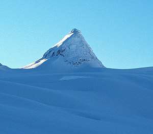 Mount Hartzell, north aspect as seen from the Matier Glacier | |
| Highest point | |
| Elevation | 2,615 m (8,579 ft) [1] |
| Prominence | 115 m (377 ft) [1] |
| Parent peak | Mount Matier (2783 m)[1] |
| Coordinates | 50°19′28″N 122°27′06″W [2] |
| Geography | |
 Mount Hartzell Location in British Columbia  Mount Hartzell Mount Hartzell (Canada) | |
| Location | Joffre Lakes Provincial Park British Columbia, Canada |
| Parent range | Joffre Group Lillooet Ranges Coast Ranges |
| Topo map | NTS 92J/8 |
| Climbing | |
| Easiest route | Scrambling, glacier travel |
Climate
Based on the Köppen climate classification, Mount Hartzell is located in a subarctic climate zone of western North America.[4]
Most weather fronts originate in the Pacific Ocean, and travel east toward the Coast Mountains where they are forced upward by the range (Orographic lift), causing them to drop their moisture in the form of rain or snowfall. As a result, the Coast Mountains experience high precipitation, especially during the winter months in the form of snowfall. Temperatures can drop below −20 °C with wind chill factors below −30 °C. The months July through September offer the most favorable weather for climbing Mount Hartzell.
Climbing Routes
Established climbing routes on Mount Hartzell:[1]
- East Face - class 3 with glacier travel
References
- "Mount Hartzell". Bivouac.com. Retrieved 2019-11-18.
- "Mount Hartzell". Geographical Names Data Base. Natural Resources Canada. Retrieved 2019-11-18.
- "Mount Hartzell". BC Geographical Names.
- Peel, M. C.; Finlayson, B. L. & McMahon, T. A. (2007). "Updated world map of the Köppen−Geiger climate classification". Hydrol. Earth Syst. Sci. 11. ISSN 1027-5606.
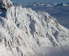
Gallery
 The Joffre Group: Joffre Peak (left), Mt. Matier (highest), Hartzell, Spetch, Slalok Mountain, Tszil, and Mt. Taylor (farthest right)
External links
- Weather: Mountain Forecast