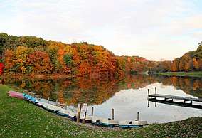
Mount Gilead State Park
Mount Gilead State Park is located in Morrow County, Ohio, United States to the east of the village of Mount Gilead. Access to the park is via State Route 95.[2]
| Mount Gilead State Park | |
|---|---|
 | |
 Location in Ohio | |
| Location | Morrow, Ohio, United States |
| Coordinates | 40°33′00″N 82°48′42″W[1] |
| Area | 181 acres (73 ha) |
| Elevation | 1,148 ft (350 m)[1] |
| Established | 1949 |
| Governing body | Ohio Department of Natural Resources Division of Parks and Recreation |
| Website | Mount Gilead State Park |
History
Work on the park began in the early 1900s, with the creation of a dam across Sam's Creek. Work continued through the proceeding decades, with a larger lake being completed below the first one on July 10, 1930. In 1949, the park was turned over to the Ohio Department of Natural Resources.[3]
Mount Gilead State Park covers 181 acres (0.73 km2), 32 of which are the lakes. It offers hiking, camping, picnicking, fishing and boating (electric motor only) opportunities.
The park's hills limit access during the winter, when vehicle access to the lakes is typically closed. (The descent is somewhat steep and features a switchback.)[4]
References
- "Mount Gilead State Park". Geographic Names Information System. United States Geological Survey.
- "Mount Gilead State Park". Ohio Department of Natural Resources. Retrieved November 17, 2017.
- "Mount Gilead State Park: History". Ohio Department of Natural Resources. Retrieved November 17, 2017.
- "Mount Gilead State Park: Activities". Ohio Department of Natural Resources. Retrieved November 17, 2017.
External links
- Mount Gilead State Park Ohio Department of Natural Resources
- Mount Gilead State Park Map Ohio Department of Natural Resources
| Wikivoyage has a travel guide for Ohio State Parks which includes Mount Gilead State Park. |