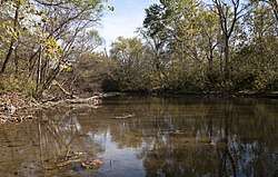
Little Darby Creek (Ohio)
The Little Darby Creek is a tributary to the Darby Creek System in central Ohio.[1] The creeks are part of the Scioto River drainage basin. Little Darby Creek runs from an area near the Lafayette-Plain City Road Bridge downstream to the confluence with Big Darby Creek near the Darby Creek Metro Park. The village of Georgesville, Ohio forms the western edge of the Confluence.
Little Darby Creek
| |
|---|---|
 | |
| Location | |
| Country | United States |
| Region | Central Ohio |
| Physical characteristics | |
| Source | |
| • coordinates | 40°06′06″N 83°36′10″W |
| Mouth | |
• location | Big Darby Creek |
• coordinates | 39°53′37″N 83°13′05″W |
• elevation | 827 ft (252 m) |
| Discharge | |
| • location | West Jefferson |
| • average | 187.6 cu ft/s (5.31 m3/s), USGS water years 1993-2019[2] |
| Type | Scenic |
| Designated | March 10, 1994 |
The Little Darby and Big Darby were listed as a state Scenic River in 1984. The creeks were listed as national Scenic Rivers in 1994.[3][4]
Little Darby Creek for many years appeared to be bigger than Big Darby Creek at their confluence. This was due to a concrete fill dam across the path of the Little Darby Creek just north of the confluence. It was locally known as Oakie's dam. The Franklin County Metro Park System later removed this structure. The Little Darby creek bed has returned to it natural condition and the presence of the dam is now very hard to detect.
See also
References
- "Little Darby Creek". Geographic Names Information System. United States Geological Survey. Retrieved August 15, 2014.
- "USGS Water-Year Summary for Site 03230310". waterdata.usgs.gov. Retrieved 2020-07-15.
- "Ohio DNR: Big & Little Darby Creek State & National Scenic River". Ohio Department of Natural Resources. Retrieved August 15, 2014.
- "Big and Little Darby Creeks, Ohio". National Wild and Scenic Rivers System. Retrieved August 15, 2014.