Mount Fox (Canada)
Mount Fox is a 2,973-metre (9,754-foot) mountain on the shared border between Alberta and British Columbia. It is situated on the Continental Divide south of the Kananaskis Lakes area of the Canadian Rockies. It was named in 1859 by John Palliser after Sir Charles Fox (1810-1874), a member of the Royal Geographical Society.[1][2]
- For the peak located in the Selkirk Mountains, see Mount Fox (British Columbia).
| Mount Fox | |
|---|---|
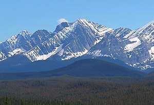 Mount Fox (centered) from the north | |
| Highest point | |
| Elevation | 2,973 m (9,754 ft) [1] |
| Prominence | 243 m (797 ft) |
| Coordinates | 50°34′12″N 115°07′06″W |
| Geography | |
 Mount Fox Location in Alberta and British Columbia  Mount Fox Mount Fox (Canada) | |
| Location | Alberta British Columbia |
| Parent range | Canadian Rockies |
| Topo map | NTS 82J/11 |
| Climbing | |
| First ascent | 1916 Interprovincial Boundary Commission |
| Easiest route | Scrambling Routes |
Geology
Mount Fox is composed of sedimentary rock laid down during the Precambrian to Jurassic periods. Formed in shallow seas, this sedimentary rock was pushed east and over the top of younger rock during the Laramide orogeny.[3]
Climate
Based on the Köppen climate classification, Mount Fox is located in a subarctic climate with cold, snowy winters, and mild summers.[4] Temperatures can drop below −20° C with wind chill factors below −30° C. In terms of favorable weather, June through September are the best months to climb it.
See also
- List of peaks on the British Columbia-Alberta border
- Mountains of Alberta
- Mountains of British Columbia
References
- "Mount Fox". PeakFinder.com. Retrieved 2019-08-20.
- "Mount Fox". Bivouac.com.
- Gadd, Ben (2008). "Geology of the Rocky Mountains and Columbias". Cite journal requires
|journal=(help) - Peel, M. C.; Finlayson, B. L. & McMahon, T. A. (2007). "Updated world map of the Köppen−Geiger climate classification". Hydrol. Earth Syst. Sci. 11: 1633–1644. ISSN 1027-5606.