Morro Peak
Morro Peak is a small 1,679-metre (5,509-foot) mountain summit located in Jasper National Park in Alberta, Canada. It is located at the northwest end of the Colin Range, which is a sub-range of the Canadian Rockies. The peak is situated 17 km (11 mi) north of the municipality of Jasper, and is a prominent landmark in the Athabasca Valley visible from Highway 16 and the Canadian. Its nearest higher peak is Hawk Mountain, 4.0 km (2.5 mi) to the southeast.[1] Morro Peak was named in 1916 by Morrison P. Bridgland for the Spanish word morro, meaning rounded hill, which is an apt description of it.[1] Bridgland (1878-1948) was a Dominion Land Surveyor who named many peaks in Jasper Park and the Canadian Rockies.[3] The mountain's name was officially adopted in 1956 by the Geographical Names Board of Canada.[2]
| Morro Peak | |
|---|---|
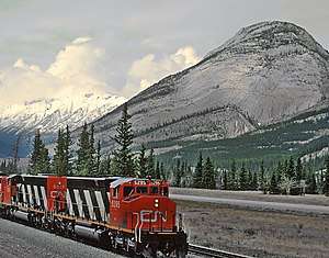 Morro Peak to the right | |
| Highest point | |
| Elevation | 1,679 m (5,509 ft) [1]> |
| Prominence | 109 m (358 ft) [1] |
| Coordinates | 53°02′00″N 118°04′04″W [2] |
| Geography | |
 Morro Peak Location of Morro Peak in Alberta  Morro Peak Morro Peak (Canada) | |
| Location | Jasper National Park Alberta, Canada |
| Parent range | Colin Range Canadian Rockies |
| Topo map | NTS 83E/01 |
| Geology | |
| Type of rock | limestone |
| Climbing | |
| Easiest route | Scrambling |
Climate
Based on the Köppen climate classification, Morro Peak is located in a subarctic climate with cold, snowy winters, and mild summers.[4] Temperatures can drop below -20 °C with wind chill factors below -30 °C. In terms of favorable weather, June through September are the best months to climb. Precipitation runoff from Morro Peak flows into the Athabasca River.
See also
- Mountains of Alberta
- Geography of Alberta
References
- "Morro Peak". Bivouac.com. Retrieved 2019-03-23.
- "Morro Peak". Geographical Names Data Base. Natural Resources Canada. Retrieved 2019-03-23.
- Mapper of Mountains M.P. Bridgland in the Canadian Rockies 1902-1930, Author I.S. MacLaren, The University of Alberta Press, ISBN 0-88864-456-6
- Peel, M. C.; Finlayson, B. L. & McMahon, T. A. (2007). "Updated world map of the Köppen−Geiger climate classification". Hydrol. Earth Syst. Sci. 11: 1633–1644. ISSN 1027-5606.
External links
- Weather forecast: Morro Peak
- Parks Canada web site: Jasper National Park