Morane (French Polynesia)
Morane[2] is an uninhabited small isolated atoll of the Tuamotu Archipelago in French Polynesia. It is located 153 km southwest of Maria Est, its closest neighbour. Morane Atoll is the southernmost atoll of the Tuamotus proper. It measures 5.8 km in length, 3.5 km in width and has a land area of 2.85 km2. The lagoon has an area of 11 km2 and has no passes. The islands on its reef are covered with screw pine (Pandanus) and coconut trees.
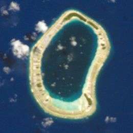 NASA picture of Morane Atoll. | |
 Morane | |
| Geography | |
|---|---|
| Location | Pacific Ocean |
| Coordinates | 23°10′S 137°08′W |
| Archipelago | Tuamotus |
| Area | 11 km2 (4.2 sq mi) (lagoon) 2.85 km2 (1.1 sq mi) (above water) |
| Length | 5.8 km (3.6 mi) |
| Width | 3.5 km (2.17 mi) |
| Administration | |
France | |
| Overseas collectivity | French Polynesia |
| Administrative subdivision | Tuamotus |
| Commune | Gambier Islands |
| Demographics | |
| Population | Uninhabited[1] (2012) |
History
The first recorded westerner to sight Morane Atoll was Captain Samuel Grimwood of the Discoverer, owned by the naturalist Hugh Cuming, on 15 January 1828. Its original name was Grimwood's Island. Cited as such in the "Pacific Island Names" atlas published by Bishop Museum Press, Hawaii, in 1986.
Administration
Administratively Morane Atoll belongs to the commune of the Gambier Islands.
Ecology
By 2003, Morane Atoll holds one of the largest extant populations (approx. 50 individuals) of the critically endangered Polynesian ground-dove.[3] It also has one of the highest concentrations of the Tuamotu sandpiper (Prosobonia cancellata), with approximately 150 to 200 individuals of the species.[4]
See also
- Desert island
- List of islands
References
- "Population". Institut de la statistique de la Polynésie française. Retrieved 9 October 2014.
- Young, J.L. (1899). "Names of the Paumotu Islands, with the old names so far as they are known". Journal of the Polynesian Society. 8 (4): 264–268. Retrieved 7 January 2015.
- "Polynesian Ground-dove (Alopecoenas erythropterus) - BirdLife species factsheet". Birdlife.org. 1999-04-30. Retrieved 2015-06-26.
- Blanvillain, Caroline; Florent, Chevallier; Thenot, Vincent (February 2002). "Land birds of Tuamotu Archipelago, Polynesia: relative abundance and changes during the 20th century with particular reference to the critically endangered Polynesian ground-dove (Gallicolumba erythroptera)". Biological Conservation. 103 (2): 139–149. doi:10.1016/S0006-3207(01)00112-4.
External links
Tuamotus Gambiers | Islands/Atolls | ||
|---|---|---|---|
| Island groups | |||