Morafenobe District
Morafenobe is a district in western Madagascar. It is a part of Melaky Region and borders the districts of Besalampy in north, Ambatomainty in east, Miandrivazo in south, Antsalova in southwest and Maintirano in west. The area is 6,976 km2 (2,693 sq mi) and the population was estimated to be 20,475 in 2001.[1]
Morafenobe District | |
|---|---|
District | |
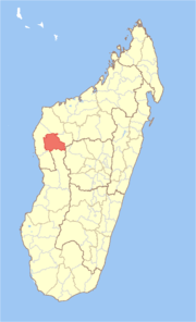 Location in Madagascar | |
| Coordinates: 16°9′S 46°37′E | |
| Country | |
| Region | Melaky |
| Area | |
| • Total | 6,976 km2 (2,693 sq mi) |
| Population (2001) | |
| • Total | 20,475 |
| • Density | 2.9/km2 (8/sq mi) |
| • Ethnicities | Sakalava |
| Time zone | UTC3 (EAT) |
The district is further divided into three communes:
References and notes
- "Madagascar Administrative units". GeoHive. Retrieved 2008-03-04.
| Antsalova | 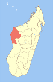 | |
|---|---|---|
| Ambatomainty |
| |
| Besalampy | ||
| Maintirano | ||
| Morafenobe | ||
gollark: For example, converting a directory of videos to a different format with `ffmpeg` or something.
gollark: Scripting capability is useful for doing random stuff a lot of times, or in bulk, and I do that occasionally.
gollark: If you *do* have to work with non-Linux stuff it probably isn't worth it.
gollark: I mean, I have a more streamlined workflow thanks to Linux permitting useful scripting and whatnot. But as a programming hobbyist only I have control of what stuff I work with and can say "not using this, it's Windows-only/inconvenient".
gollark: Yes, it doesn't work for everything and the UI is kind of bad.
This article is issued from Wikipedia. The text is licensed under Creative Commons - Attribution - Sharealike. Additional terms may apply for the media files.