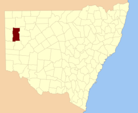
Parish of Bomgadah
Bomgadah located at 31°25′02″S 141°44′53″ is a remote civil parish of Mootwingee County in far North West New South Wales.[1]
Geography
The Geography, of the Parish is mostly the flat, arid scrubland. The parish has a Köppen climate classification of BWh (Hot desert)[2]. The nearest town is Broken Hill, New South Wales. The Parish is on the Silver City Highway, Tibooburra is to the north and Whitecliffs to the east.
The Parish is on the traditional lands of the Bandjigali peoples[3] Aboriginal peoples.[4]
gollark: Although that might make sense, so C probably does something else.
gollark: I would assume the value of `m[4]` after addition.
gollark: More seriously, though, probably `m[4]` plus 8 times `m[3]` plus 40.
gollark: it evaluates toYOUR DOOM
gollark: and you probably could.
References
- "Mootwingee County". Geographical Names Register (GNR) of NSW. Geographical Names Board of New South Wales.

- Peel, M. C.; Finlayson, B. L.; McMahon, T. A. (2007). "Updated world map of the Köppen–Geiger climate classification". Hydrol. Earth Syst. Sci. 11: 1633–1644. doi:10.5194/hess-11-1633-2007. ISSN 1027-5606. (direct: Final Revised Paper)
- Tindale, Norman Barnett (1974). Aboriginal Tribes of Australia: Their Terrain, Environmental Controls, Distribution, Limits, and Proper Names. Australian National University Press. p196.
- David R Horton (creator), Aboriginal Studies Press, AIATSIS, and Auslig/Sinclair, Knight, Merz, 1996.
This article is issued from Wikipedia. The text is licensed under Creative Commons - Attribution - Sharealike. Additional terms may apply for the media files.