Montverde, Florida
Montverde is a town in Lake County, Florida, United States. The population was 1,463 at the 2010 census[6] and an estimated 1,675 in 2018.[7] It is part of the Orlando–Kissimmee–Sanford Metropolitan Statistical Area.
Montverde, Florida | |
|---|---|
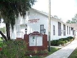
 Montverde town hall | |
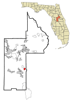
 Location in Lake County and the state of Florida | |
| Coordinates: 28°35′58″N 81°40′34″W | |
| Country | |
| State | |
| County | |
| Government | |
| • Mayor | Joe Wynkoop[1] |
| Area | |
| • Total | 1.88 sq mi (4.88 km2) |
| • Land | 1.67 sq mi (4.34 km2) |
| • Water | 0.21 sq mi (0.54 km2) |
| Elevation | 108 ft (33 m) |
| Population (2010) | |
| • Total | 1,463 |
| • Estimate (2019)[3] | 1,705 |
| • Density | 1,018.52/sq mi (393.23/km2) |
| Time zone | UTC-5 (Eastern (EST)) |
| • Summer (DST) | UTC-4 (EDT) |
| ZIP code | 34756 |
| Area code(s) | 407, 689 |
| FIPS code | 12-46525[4] |
| GNIS feature ID | 0287081[5] |
| Website | www |
History
Montverde is the location of a Native American burial ground. The earliest record of American settlement is from 1865. Initially named "West Lake Apopka", the site took the name "Monte Verde" from a settler from Vermont who remarked on its rolling green hills while arriving at the site by boat on Lake Apopka. The town of Montverde was incorporated on May 18, 1925.[8]
The central feature of the town is Montverde Academy, a private preparatory school for primary and secondary students. The school was opened in 1912.
Geography
Montverde is located in southeastern Lake County at 28°35′58″N 81°40′34″W,[9] on the southwest shore of Lake Apopka. The town sits on hills that rise 50 to 100 feet (15 to 30 m) above the elevation of the lake. It is 18 miles (29 km) south of Tavares, the Lake county seat, and 24 miles (39 km) northwest of Orlando.
According to the United States Census Bureau, the town of Montverde has a total area of 1.9 square miles (4.9 km2), of which 1.7 square miles (4.3 km2) are land and 0.2 square miles (0.5 km2), or 11.10%, are water.[10]
Demographics
| Historical population | |||
|---|---|---|---|
| Census | Pop. | %± | |
| 1930 | 297 | — | |
| 1940 | 312 | 5.1% | |
| 1950 | 293 | −6.1% | |
| 1960 | 374 | 27.6% | |
| 1970 | 308 | −17.6% | |
| 1980 | 397 | 28.9% | |
| 1990 | 890 | 124.2% | |
| 2000 | 882 | −0.9% | |
| 2010 | 1,463 | 65.9% | |
| Est. 2019 | 1,705 | [3] | 16.5% |
| U.S. Decennial Census[11] | |||
At the 2000 census there were 882 people, 351 households, and 272 families living in the town. The population density was 561.5 people per square mile (216.9/km2). There were 410 housing units at an average density of 261.0 per square mile (100.8/km2). The racial makeup of the town was 96.49% White, 1.59% African American, 0.23% Native American, 0.45% Asian, 0.11% from other races, and 1.13% from two or more races. Hispanic or Latino of any race were 2.61%.[4]
Of the 351 households 27.6% had children under the age of 18 living with them, 66.4% were married couples living together, 8.5% had a female householder with no husband present, and 22.5% were non-families. 19.7% of households were one person and 5.7% were one person aged 65 or older. The average household size was 2.51 and the average family size was 2.89.
The age distribution was 22.3% under the age of 18, 6.8% from 18 to 24, 29.9% from 25 to 44, 27.0% from 45 to 64, and 13.9% 65 or older. The median age was 41 years. For every 100 females, there were 97.3 males. For every 100 females age 18 and over, there were 94.6 males.
The median household income was $45,341 and the median family income was $46,813. Males had a median income of $35,774 versus $26,944 for females. The per capita income for the town was $20,504. About 4.5% of families and 5.3% of the population were below the poverty line, including 7.1% of those under age 18 and 12.0% of those age 65 or over.
Notable person
Ruben Wyatt Harper, pioneer citrus grower and community leader. Harper is listed as a Great Floridian 2000 by the State of Florida. The historic Harper House is listed on the National Register of Historic Places.Ben Simmons, Small Forward for the Philadelphia 76ers.
References
- https://mymontverde.com/town-hall-montverde-fl/
- "2019 U.S. Gazetteer Files". United States Census Bureau. Retrieved July 2, 2020.
- "Population and Housing Unit Estimates". United States Census Bureau. May 24, 2020. Retrieved May 27, 2020.
- "U.S. Census website". United States Census Bureau. Retrieved 2008-01-31.
- "US Board on Geographic Names". United States Geological Survey. 2007-10-25. Retrieved 2008-01-31.
- "Profile of General Population and Housing Characteristics: 2010 Census Summary File 1 (DP-1), Montverde town, Florida". American FactFinder. U.S. Census Bureau. Archived from the original on February 13, 2020. Retrieved November 12, 2019.
- "Annual Estimates of the Resident Population for Incorporated Places: April 1, 2010 to July 1, 2018: Incorporated Places: Florida". Archived from the original on February 13, 2020. Retrieved November 12, 2019.
- https://mymontverde.com/about-montverde-florida/
- "US Gazetteer files: 2010, 2000, and 1990". United States Census Bureau. 2011-02-12. Retrieved 2011-04-23.
- "U.S. Gazetteer Files: 2019: Places: Florida". U.S. Census Bureau Geography Division. Retrieved November 12, 2019.
- "Census of Population and Housing". Census.gov. Retrieved June 4, 2015.
