Montcalm, Quebec
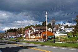
Montcalm is a municipality in the Les Laurentides Regional County Municipality of Quebec southeast of Mont-Tremblant. The main population centre in Montcalm is the village of Weir.
Montcalm | |
|---|---|
Municipality | |
 Weir | |
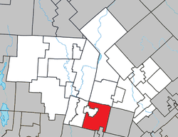 Location within Les Laurentides RCM | |
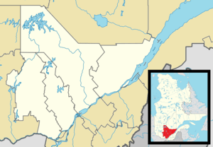 Montcalm Location in central Quebec | |
| Coordinates: 45°58′N 74°30′W[1] | |
| Country | |
| Province | |
| Region | Laurentides |
| RCM | Les Laurentides |
| Constituted | March 6, 1907 |
| Government | |
| • Mayor | Steven Larose |
| • Federal riding | Laurentides—Labelle |
| • Prov. riding | Argenteuil |
| Area | |
| • Total | 129.30 km2 (49.92 sq mi) |
| • Land | 117.18 km2 (45.24 sq mi) |
| Population (2011)[3] | |
| • Total | 619 |
| • Density | 5.3/km2 (14/sq mi) |
| • Pop 2006-2011 | |
| • Dwellings | 663 |
| Time zone | UTC−5 (EST) |
| • Summer (DST) | UTC−4 (EDT) |
| Postal code(s) | J0T 2V0 |
| Area code(s) | 819 |
| Highways | |
| Website | www.municipalite. montcalm.qc.ca |
Demographics
Population trend:[4]
- Population in 2011: 619 (2006 to 2011 population change: -5.1%)
- Population in 2006: 652
- Population in 2001: 534
- Population in 1996: 449
- Population in 1991: 369
Private dwellings occupied by usual residents: 308 (total dwellings: 663)
Mother tongue:
- English as first language: 25%
- French as first language: 73.5%
- English and French as first language: 1.5%
- Other as first language: 0%
Weir
Weir (45°56′42″N 74°32′58″W) is an unincorporated village in Montcalm, accessible via Quebec Route 364. It is home to a satellite earth station for VSNL International Canada.
Weir is named after William Alexander Weir (1858-1929), a Quebec politician and judge.[5]
Education
Sir Wilfrid Laurier School Board operates English-language schools:
- Arundel Elementary School in Arundel[6]
- Laurentian Regional High School in Lachute serves almost all of Montcalm[7]
gollark: Instead of forgetting to remember, just forget to forget.
gollark: Fun!
gollark: Well, it turns out that in real reality™, making things think turned out waaaay harder than moving things around and manufacturing things and such, and the things we have gotten out of this are not remotely humanlike or peoplelike.
gollark: ???
gollark: ↓ you, as a result
References
- Reference number 274200 of the Commission de toponymie du Québec (in French)
- Geographic code 78055 in the official Répertoire des municipalités (in French)
- "(Code 2478055) Census Profile". 2011 census. Statistics Canada. 2012.
- Statistics Canada: 1996, 2001, 2006, 2011 census
- Commission de toponymie du Quebec - Weir
- "Arundel Elementary Zone." Sir Wilfrid Laurier School Board. Retrieved on September 16, 2017.
- "LAURENTIAN REGIONAL HS ZONE." Sir Wilfrid Laurier School Board. Retrieved on September 4, 2017.
External links

- Municipalité de Montcalm
- Atlas of Canada - Montcalm
- Commission de toponymie du Quebec
Places adjacent to Montcalm, Quebec | ||||||||||
|---|---|---|---|---|---|---|---|---|---|---|
| ||||||||||
| Cities/towns | |
|---|---|
| Municipalities | |
| Townships | |
| Parishes | |
| Villages | |
| |
This article is issued from Wikipedia. The text is licensed under Creative Commons - Attribution - Sharealike. Additional terms may apply for the media files.