Labelle, Quebec
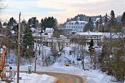
Labelle is a village and municipality in the Laurentides region of Quebec, Canada, part of the Les Laurentides Regional County Municipality. Its large "L"-shaped territory surrounds Lake Labelle, and the village is located along the Rouge River and Route 117.
Labelle | |
|---|---|
Municipality | |
 | |
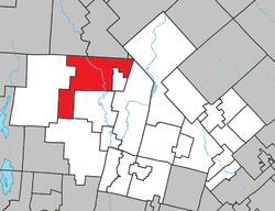 Location within Les Laurentides RCM | |
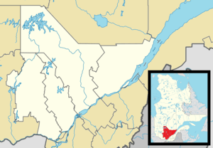 Labelle Location in central Quebec | |
| Coordinates: 46°17′N 74°44′W[1] | |
| Country | |
| Province | |
| Region | Laurentides |
| RCM | Les Laurentides |
| Constituted | January 27, 1973 |
| Government | |
| • Mayor | Gilbert Brassard |
| • Federal riding | Laurentides—Labelle |
| • Prov. riding | Labelle |
| Area | |
| • Total | 216.30 km2 (83.51 sq mi) |
| • Land | 198.79 km2 (76.75 sq mi) |
| Population (2011)[3] | |
| • Total | 2,445 |
| • Density | 12.3/km2 (32/sq mi) |
| • Pop 2006-2011 | |
| • Dwellings | 1,753 |
| Time zone | UTC−5 (EST) |
| • Summer (DST) | UTC−4 (EDT) |
| Postal code(s) | J0T 1H0 |
| Area code(s) | 819 |
| Highways | |
| Website | www.municipalite .labelle.qc.ca |
Demographics
Population trend:[4]
- Population in 2011: 2445 (2006 to 2011 population change: 8.3%)
- Population in 2006: 2258
- Population in 2001: 2272
- Population in 1996: 2256 (or 2271 when adjusted for 2001 boundaries)
- Population in 1991: 2090
Private dwellings occupied by usual residents: 1115 (total dwellings: 1753)
Mother tongue:
- English as first language: 0.5%
- French as first language: 97%
- English and French as first language: 0.7%
- Other as first language: 1.8%
Education
Sainte Agathe Academy (of the Sir Wilfrid Laurier School Board) in Sainte-Agathe-des-Monts serves English-speaking students in this community for both elementary and secondary levels.[5]
gollark: APIONET is eternal.
gollark: > see i wanna beat someone up but i dont want to start a fight soJust become a bully and beat up those weaker than you!
gollark: Do boxing?]
gollark: VM ethernet platform hacked.
gollark: Synthesizing UDP unicode microchip...
References
- Reference number 32796 of the Commission de toponymie du Québec (in French)
- Geographic code 78120 in the official Répertoire des municipalités (in French)
- "(Code 2478120) Census Profile". 2011 census. Statistics Canada. 2012.
- Statistics Canada: 1996, 2001, 2006, 2011 census
- "About Us." Saint Agathe Academy. Retrieved on September 4, 2017. See Elementary zone map and Secondary zone map - Note that all areas covered in the elementary map are also covered in the secondary one.
External links

Places adjacent to Labelle, Quebec | ||||||||||
|---|---|---|---|---|---|---|---|---|---|---|
| ||||||||||
| Cities/towns | |
|---|---|
| Municipalities | |
| Townships | |
| Parishes | |
| Villages | |
| |
| Authority control |
|
|---|
This article is issued from Wikipedia. The text is licensed under Creative Commons - Attribution - Sharealike. Additional terms may apply for the media files.