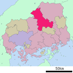
Miyoshi, Hiroshima
Miyoshi (三次市, Miyoshi-shi) is a city located in Hiroshima Prefecture, Japan. The city was founded on March 31, 1954.
Miyoshi 三次市 | |
|---|---|
Miyoshi City, Museum of Art | |
 Flag  Emblem | |
 Location of Miyoshi in Hiroshima Prefecture | |
 Miyoshi Location in Japan | |
| Coordinates: 34°48′N 132°51′E | |
| Country | Japan |
| Region | Chūgoku (San'yō) |
| Prefecture | Hiroshima Prefecture |
| Government | |
| • Mayor | Kazutoshi Masuda (since May 2011) |
| Area | |
| • Total | 778.19 km2 (300.46 sq mi) |
| Population (May 1, 2017) | |
| • Total | 53,616 |
| • Density | 69/km2 (180/sq mi) |
| Symbols | |
| • Tree | Maple |
| • Flower | Sakura |
| • Bird | Japanese wagtail |
| Time zone | UTC+9 (JST) |
| City hall address | 2-8-1, Tōkaichi Naka, Miyoshi-shi, Hiroshima-ken 728-8501 |
| Website | www |
As of May 2017, the city has an estimated population of 53,616 and a population density of 69 persons per km2.[1] The total area is 778 km2.
On April 1, 2004, Miyoshi absorbed the towns of Kisa, Mirasaka and Miwa, the villages of Funo, Kimita and Sakugi (all from Futami District), and the town of Kōnu (from Kōnu District) to create the new and expanded city of Miyoshi. Futami District was dissolved as a result of this merger.
Climate
| Climate data for Miyoshi (三次町) | |||||||||||||
|---|---|---|---|---|---|---|---|---|---|---|---|---|---|
| Month | Jan | Feb | Mar | Apr | May | Jun | Jul | Aug | Sep | Oct | Nov | Dec | Year |
| Record high °C (°F) | 16.6 (61.9) |
21.1 (70.0) |
24.8 (76.6) |
31.1 (88.0) |
33.3 (91.9) |
35.2 (95.4) |
37.2 (99.0) |
37.2 (99.0) |
36.9 (98.4) |
30.4 (86.7) |
25.1 (77.2) |
18.9 (66.0) |
37.2 (99.0) |
| Average high °C (°F) | 6.6 (43.9) |
8.0 (46.4) |
12.4 (54.3) |
19.2 (66.6) |
23.9 (75.0) |
27.1 (80.8) |
30.3 (86.5) |
31.8 (89.2) |
27.3 (81.1) |
21.5 (70.7) |
15.2 (59.4) |
9.3 (48.7) |
19.4 (66.9) |
| Daily mean °C (°F) | 1.7 (35.1) |
2.5 (36.5) |
6.0 (42.8) |
11.8 (53.2) |
16.8 (62.2) |
21.0 (69.8) |
24.8 (76.6) |
25.6 (78.1) |
21.3 (70.3) |
14.6 (58.3) |
8.7 (47.7) |
3.8 (38.8) |
13.2 (55.8) |
| Average low °C (°F) | −1.7 (28.9) |
−1.6 (29.1) |
0.6 (33.1) |
5.1 (41.2) |
10.5 (50.9) |
16.0 (60.8) |
20.7 (69.3) |
21.2 (70.2) |
17.0 (62.6) |
10.0 (50.0) |
4.3 (39.7) |
0.1 (32.2) |
8.5 (47.3) |
| Record low °C (°F) | −10.8 (12.6) |
−12.5 (9.5) |
−7.5 (18.5) |
−3.6 (25.5) |
0.2 (32.4) |
7.7 (45.9) |
10.7 (51.3) |
13.9 (57.0) |
5.7 (42.3) |
0.5 (32.9) |
−2.3 (27.9) |
−10.2 (13.6) |
−12.5 (9.5) |
| Average precipitation mm (inches) | 65.2 (2.57) |
73.4 (2.89) |
106.6 (4.20) |
107.6 (4.24) |
147.0 (5.79) |
210.3 (8.28) |
259.0 (10.20) |
123.4 (4.86) |
171.5 (6.75) |
87.9 (3.46) |
71.7 (2.82) |
68.5 (2.70) |
1,492.1 (58.76) |
| Average precipitation days (≥ 1.0 mm) | 12.7 | 11.9 | 12.0 | 10.2 | 10.5 | 11.6 | 12.5 | 8.9 | 10.3 | 7.6 | 9.1 | 11.4 | 128.7 |
| Mean monthly sunshine hours | 80.3 | 98.1 | 137.8 | 172.3 | 186.7 | 146.5 | 159.0 | 181.5 | 136.3 | 136.5 | 101.7 | 81.9 | 1,624 |
| Source: 気象庁 | |||||||||||||
gollark: I also have a ridiculously gigantic DEFLATE thing tweaked slightly from jackmacwindows's port of some WoW developer's thing.
gollark: Would adding the LZW library potatOS uses be useful? It's basically a minimal compression thing.
gollark: Maybe libdatatape would be useful if I swap out the random proprietary (and mostly made by someone else and tweaked by me because it did integers wrong) serialization format for CBOR, or let you provide your own.
gollark: I think a big one is RXI's JSON thing, although that got obsoleted on newer versions by `textutils.unserialiseJSON` or whatever it is.
gollark: The particularly good ones are generally from other people.
References
- "Official website of Miyoshi City" (in Japanese). Japan: Miyoshi City. Retrieved 17 May 2017.
External links
- Miyoshi City official website (in Japanese)
This article is issued from Wikipedia. The text is licensed under Creative Commons - Attribution - Sharealike. Additional terms may apply for the media files.