Missouri Township, Brown County, Illinois
Missouri Township is one of nine townships in Brown County, Illinois, USA. As of the 2010 census, its population was 143 and it contained 89 housing units.[2]
Missouri Township | |
|---|---|
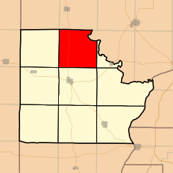 Location in Brown County | |
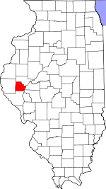 Brown County's location in Illinois | |
| Coordinates: 40°03′39″N 90°44′41″W | |
| Country | United States |
| State | Illinois |
| County | Brown |
| Established | November 8, 1853 |
| Area | |
| • Total | 35.44 sq mi (91.8 km2) |
| • Land | 35.44 sq mi (91.8 km2) |
| • Water | 0 sq mi (0 km2) 0% |
| Elevation | 669 ft (204 m) |
| Population (2010) | |
| • Estimate (2016)[1] | 139 |
| • Density | 4/sq mi (2/km2) |
| Time zone | UTC-6 (CST) |
| • Summer (DST) | UTC-5 (CDT) |
| ZIP code | 62353 |
| FIPS code | 17-009-49685 |
Geography
According to the 2010 census, the township has a total area of 35.44 square miles (91.8 km2), all land.[2]
Cemeteries
The township contains these eight cemeteries: Beans, Bell, Clark, Glasgow Farm, Kinman Burial Ground, Linn-Walker Graves, Miller Land and Rigg.
Major highways
School districts
- Brown County Community Unit School District 1
Political districts
- Illinois' 18th congressional district
- State House District 93
- State Senate District 47
gollark: Rust has a nice `?` operator for error handling.
gollark: No.
gollark: See? Three if err != nils.
gollark: That is horrible syntax.
gollark: It does have advantages, like being easy to parallelize and stuff.
References
- "Missouri Township, Brown County, Illinois". Geographic Names Information System. United States Geological Survey. Retrieved 2010-01-04.
- United States Census Bureau 2007 TIGER/Line Shapefiles
- United States National Atlas
- "Population and Housing Unit Estimates". Retrieved June 9, 2017.
- "Population, Housing Units, Area, and Density: 2010 - County -- County Subdivision and Place -- 2010 Census Summary File 1". United States Census. Archived from the original on 2020-02-12. Retrieved 2013-05-28.
- "Census of Population and Housing". Census.gov. Retrieved June 4, 2016.
External links
Places adjacent to Missouri Township, Brown County, Illinois | |
|---|---|
Municipalities and communities of Brown County, Illinois, United States | ||
|---|---|---|
| Cities | Map of Illinois highlighting Brown County | |
| Villages | ||
| Townships | ||
| Unincorporated communities | ||
| Ghost towns | ||
This article is issued from Wikipedia. The text is licensed under Creative Commons - Attribution - Sharealike. Additional terms may apply for the media files.