Duncan, Mississippi
Duncan is a town in Bolivar County, Mississippi, United States. The population was 423 at the 2010 census,[3] down from 578 in 2000.
Duncan, Mississippi | |
|---|---|
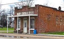
 Duncan Town Hall | |
 Location of Duncan, Mississippi | |
 Duncan, Mississippi Location in the United States | |
| Coordinates: 34°2′32″N 90°44′48″W | |
| Country | United States |
| State | Mississippi |
| County | Bolivar |
| Area | |
| • Total | 0.92 sq mi (2.37 km2) |
| • Land | 0.92 sq mi (2.37 km2) |
| • Water | 0.00 sq mi (0.00 km2) |
| Elevation | 154 ft (47 m) |
| Population (2010) | |
| • Total | 423 |
| • Estimate (2019)[2] | 380 |
| • Density | 414.85/sq mi (160.21/km2) |
| Time zone | UTC-6 (Central (CST)) |
| • Summer (DST) | UTC-5 (CDT) |
| ZIP code | 38740 |
| Area code(s) | 662 |
| FIPS code | 28-20380 |
| GNIS feature ID | 0669500 |
History
Duncan is named for an early "leading citizen."[4]
Geography
According to the United States Census Bureau, the town has a total area of 0.9 square miles (2.3 km2), all land.[5]
Demographics
| Historical population | |||
|---|---|---|---|
| Census | Pop. | %± | |
| 1900 | 172 | — | |
| 1910 | 284 | 65.1% | |
| 1920 | 322 | 13.4% | |
| 1930 | 337 | 4.7% | |
| 1940 | 419 | 24.3% | |
| 1950 | 436 | 4.1% | |
| 1960 | 465 | 6.7% | |
| 1970 | 599 | 28.8% | |
| 1980 | 501 | −16.4% | |
| 1990 | 416 | −17.0% | |
| 2000 | 578 | 38.9% | |
| 2010 | 423 | −26.8% | |
| Est. 2019 | 380 | [2] | −10.2% |
| U.S. Decennial Census[6] | |||
As of the census[7] of 2000, there were 578 people, 177 households, and 124 families residing in the town. The population density was 620.7 people per square mile (240.0/km2). There were 186 housing units at an average density of 199.7 per square mile (77.2/km2). The racial makeup of the town was 19.55% White, 77.51% African American, 2.25% from other races, and 0.69% from two or more races. Hispanic or Latino of any race were 3.11% of the population.
There were 177 households, out of which 42.4% had children under the age of 18 living with them, 36.2% were married couples living together, 26.0% had a female householder with no husband present, and 29.4% were non-families. 24.3% of all households were made up of individuals, and 11.3% had someone living alone who was 65 years of age or older. The average household size was 2.95 and the average family size was 3.47.
In the town, the population was spread out, with 33.4% under the age of 18, 7.1% from 18 to 24, 25.1% from 25 to 44, 18.3% from 45 to 64, and 16.1% who were 65 years of age or older. The median age was 33 years. For every 100 females, there were 87.7 males. For every 100 females age 18 and over, there were 86.9 males.
The median income for a household in the town was $14,286, and the median income for a family was $16,875. Males had a median income of $24,750 versus $11,429 for females. The per capita income for the town was $8,329. About 51.1% of families and 58.6% of the population were below the poverty line, including 75.4% of those under age 18 and 29.6% of those age 65 or over.
Education
Duncan is served by the North Bolivar Consolidated School District (formerly the North Bolivar School District). Area schools include:
- Brooks Elementary School
- Shelby Middle School (in Shelby)
- Broad Street High School (in Shelby)
It was also in the former North Bolivar School District.[8] On July 1, 2014, the North Bolivar School District consolidated with the Mound Bayou Public School District to form the North Bolivar Consolidated School District.[9]
Notable people
- Eddie C. Campbell, musician
- Bobby Crespino, former tight end for the Cleveland Browns and New York Giants
- Willie Love, musician
Further reading
- Miles, Loyce Braswell. “Duncan, Mississippi: The Origins and Survival of a Town,” Journal of the Bolivar County Historical Society, pp. 5–7 (March 1983).
References
- "2019 U.S. Gazetteer Files". United States Census Bureau. Retrieved July 26, 2020.
- "Population and Housing Unit Estimates". United States Census Bureau. May 24, 2020. Retrieved May 27, 2020.
- "Geographic Identifiers: 2010 Demographic Profile Data (G001): Duncan town, Mississippi". U.S. Census Bureau, American Factfinder. Archived from the original on February 12, 2020. Retrieved January 22, 2014.
- Gannett, Henry (1905). The Origin of Certain Place Names in the United States. Govt. Print. Off. pp. 110.
- "US Gazetteer files: 2010, 2000, and 1990". United States Census Bureau. 2011-02-12. Retrieved 2011-04-23.
- "Census of Population and Housing". Census.gov. Retrieved June 4, 2015.
- "U.S. Census website". United States Census Bureau. Retrieved 2008-01-31.
- "SCHOOL DISTRICT REFERENCE MAP (2010 CENSUS): Bolivar County, MS." U.S. Census Bureau. Retrieved on May 25, 2018.
- "School District Consolidation in Mississippi Archived 2017-07-02 at the Wayback Machine." Mississippi Professional Educators. December 2016. Retrieved on July 2, 2017. Page 2 (PDF p. 3/6).
