Mirzapur
Mirzapur ![]()
Mirzapur | |
|---|---|
City | |
 Bariya Ghat | |
 Mirzapur  Mirzapur  Mirzapur | |
| Coordinates: 25.146°N 82.569°E | |
| Country | |
| State | Uttar Pradesh |
| Government | |
| • Divisional Commissioner | A.K.Singh (IAS) |
| • District Magistrate | Susheel Kumar Patel (IAS) |
| • Member of Lok Sabha | Anupriya Singh Patel (Apna Dal) |
| Elevation | 80 m (260 ft) |
| Population (2011)[1] | |
| • City | 233,691 |
| • Density | 567/km2 (1,470/sq mi) |
| • Metro | 245,817 |
| Language | |
| • Official | Hindi[3] |
| • Additional official | Urdu[3] |
| Time zone | UTC+5:30 (IST) |
| PIN | 231001 |
| Telephone code | 05442 |
| Vehicle registration | UP-63 |
| Sex ratio | 0.903 (2011) |
| Literacy | 68.48% (2011) (78.97%♂; 56.86%♀) |
| Website | www |
Politics
A step towards the awareness for voting the District of Mirzapur came with the Guinness World Record for the biggest Rangoli (Alpana) created in an area of 39,125 m2 using approx 120,000 kg of color by across 3500 students and teachers from 50 schools on occasion of National Voters Day.[6] This city is situated at bank of river Ganga.
Geography
Mirzapur is located at 25.15°N 82.58°E.[7] It has an average elevation of 80 metres (265 feet). The District of Mirzapur lies between the parallels of 23.52 & 25.32 North latitude and 82.7 and 83.33 East longitude. It forms a portion of the Varanasi district. On the north and north-east it is bounded by the Varanasi district; on the south bounded by Sonbhadra district; on the north-west by Allahabad district. The shape to the north and west is totally regular. In no direction, except for about 13 km. in the north-east where the Ganges separates the Tehsil of Chunar from the district of Varanasi, has Mirzapur a natural frontier. The Chanvar fields, considered to be one of the most fertile lands tracts in India, are located on Gangetic flood plains of the district. Also, Indian Standard Time is calculated on the basis of 82.5° E longitude, from a clock tower in Mirzapur
According to Central Statistical organisation the district of Mirzapur had an area of 4521 km2.
Some geographical locations around Mirzapur district is depicted below
Places adjacent to Mirzapur | ||||||||||
|---|---|---|---|---|---|---|---|---|---|---|
| ||||||||||
Demographics
As of the 2011 census, Mirzapur-cum-Vindhyachal municipality had a population of 233,691[1] and the urban agglomeration had a population of 245,817.[2] The municipality had a sex ratio of 869 females per 1,000 males and 11.9% of the population were under six years old.[1] Effective literacy was 78.25%; male literacy was 83.85% and female literacy was 71.80%.[1]
Commerce
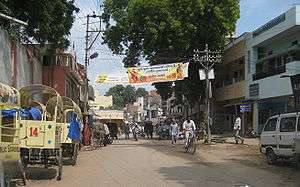
The main business in Mirzapur is carpet manufacturing. Manufacturers range from very small (with less than $100,000 in assets) to medium-sized (with around $10M in assets). Most of the carpets are sold internationally as India has a limited market for carpets. The second main business is of metal pots (brass).
Indian Standard Time calculation
Indian Standard Time is calculated from the clock tower in Mirzapur nearly exactly on the reference longitude of Indian Standard Time at 82.5°, within 4 angular minutes, a property shared by Tuni, a town in Andhra Pradesh.[8]
Tourism
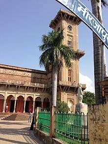
For quite some years Mirzapur has been a destination for tourists, particularly for people from adjoining states, owing mainly to the ghats, temples, the famous clock tower(Ghanta Ghar)which are excellent examples of contemporary architecture.[9][10]
Temples and mosques
- Vindhyachal
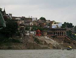
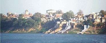
A few miles away from the city is a site of a pilgrimage for Hindus known as Vindhyachal where according to the mythology a part of Sati (an Avatar of Durga) fell. The river Ganges flows through this city. Other sites of pilgrimage include Kali Khoh (literally 'the cave of the Goddess Kali') where a statue of the Kali has a mouth formed in the shape of a cave, hence the name. Very close to the city is a waterfall. The city itself has many Ghats (steps to a river).
- Ghanta Ghar (Clock Tower)
The famous Ghanta Ghar of Mirzapur is located in the premises of city corporation, about 3 km from the Mirzapur Railway Station. Currently not functioning, it was constructed in the year 1891, with its entire structure made up of finely carved stone and a 1000 kg alloy bell hanging from the tall structure.
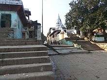
Ghats
Ojhala Bridge
The Ojhala Bridge was constructed by Mahant Parshuram Giri in Vikram Samvat 1772. This valuable heritage connecting the cities of Mirzapur and Vindhyachal, with fort like minarets and ramparts on the either side of the bridge, provide a fine instance of contemporary architecture.
Pakka Ghat Another very popular ghat in Mirzapur is Pakka Ghat known for vide variety of shops on both side of staircases descending towards the Ganges. The shops include jewellery, makeup & beauty, clothing and footwear etc.

Education
Mirzapur benefitted as University known as Rajiv Gandhi South Campus at Barkachha[11] acquired by BHU, on lease in perpetuity from Bharat Mandal Trust[12] in April 1979 with an area of 1104 hectare situated about 8 km South West of Mirzapur City. At present RGSC (Rajiv Gandhi South Campus) is spread over 2700 acres and has been used to run special courses of Banaras Hindu University. Ambika Devi Senior Secondary School in Panwari Kalan is also located in Mizapur.[13]
In popular culture
- The web series Mirzapur is primarily shot in the city of Mirzapur
See also
- Amoi
- Kewtaveer
- Khulua
- Chhitampatti
- Mirzapur District
References
- "Provisional Population Totals, Census of India 2011; Cities having population 1 lakh and above" (PDF). Office of the Registrar General & Census Commissioner, India. Retrieved 26 March 2012.
- "Provisional Population Totals, Census of India 2011; Urban Agglomerations/Cities having population 1 lakh and above" (PDF). Office of the Registrar General & Census Commissioner, India. Retrieved 26 March 2012.
- "52nd Report of the Commissioners for Linguistic Minorities in India" (PDF). nclm.nic.in. Ministry of Minority Affairs. Archived from the original (PDF) on 25 May 2017. Retrieved 26 December 2018.
- "Google Maps". Google Maps. Retrieved 23 May 2017.
- "Google Maps". Google Maps. Retrieved 23 May 2017.
- Singh, Binay (25 January 2017). "Naxal hit Mirzapur attempts Guinness world record for the biggest rangoli | Varanasi News - Times of India". The Times of India.
- Falling Rain Genomics, Inc – Mirzapur. Fallingrain.com. Retrieved on 1 June 2012.
- India investigates different time zones. BBC. 21 August 2001
- added on 23 June 2013
- added on 23 June 2013
- "Rajiv Gandhi South Campus".
- "BHU South Campus".
- "Ambika Devi Senior Secondary School". Retrieved 13 February 2019.
External links
| Wikivoyage has a travel guide for Mirzapur. |
| Wikimedia Commons has media related to Mirzapur, Uttar Pradesh. |