Miquelon-Langlade
Miquelon-Langlade is the larger and less populated of the two communes (municipalities) making up the French overseas collectivity of Saint Pierre and Miquelon, located to the south of Newfoundland in the Gulf of St. Lawrence.[2] It consists of three geological islands: Miquelon, Langlade and Le Cap, connected with tombolos. The communal seat is the settlement of Miquelon, on the northern tip, where the entire island's permanent population of 591 (as of 2017) is located. Miquelon Airport provides flights to Montreal and to nearby Saint-Pierre.
Miquelon-Langlade | |
|---|---|
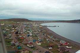 Aerial view of Miquelon town | |
 | |
Location of Miquelon-Langlade 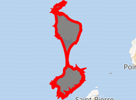
| |
| Coordinates: 47°06′00″N 56°22′45″W | |
| Country | France |
| Overseas collectivity | Saint Pierre and Miquelon |
| Government | |
| • Mayor (2014-2020) | Jean de Lizarraga |
| Area | 205 km2 (79 sq mi) |
| Population (2017)[1] | 591 |
| • Density | 2.9/km2 (7.5/sq mi) |
| Time zone | UTC−03:00 |
| • Summer (DST) | UTC−02:00 |
| INSEE/Postal code | 97501 /97500 |
| Elevation | 0–240 m (0–787 ft) |
Geography
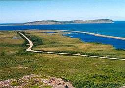
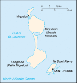
Located in the Gulf of St. Lawrence, west of Newfoundland's Burin Peninsula, Miquelon-Langlade covers a total land area of 205 km2 (79 sq mi). It is made up of three geologically distinct islands bound together by tombolos — long strips of sand dune — Le Cap in the north, Miquelon (Grand Miquelon) in the centre and Langlade (Petite Miquelon) in the south.
On the south of the Miquelon Island is a large lagoon known as the Grand Barachois which is host to a large population of seals and other wildlife. Miquelon is also a well known destination for bird watching.
An 8 mi (13 km) long tombolo sandspit called La Dune connects Miquelon and Langlade.[3] In the eighteenth century it was still possible to sail a boat between Miquelon and Langlade, but by the end of that century La Dune had closed in to form an isthmus between the islands.[4]
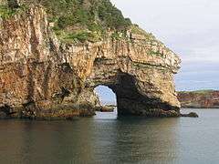
Located at 3 mi (4.8 km) west of Saint Pierre Island, Langlade is an ancient peneplain drained by numerous short rivers, including the Belle, the largest, which flows to the northwest.[5] The coast of Langlade is lined with steep cliffs, except to the northwest.
Climate
Köppen–Geiger climate classification system classifies its climate as subarctic (Dfc).[6] Summers are mild while winters are cold. It receives precipitation all year.
| Climate data for Miquelon-Langlade | |||||||||||||
|---|---|---|---|---|---|---|---|---|---|---|---|---|---|
| Month | Jan | Feb | Mar | Apr | May | Jun | Jul | Aug | Sep | Oct | Nov | Dec | Year |
| Average high °C (°F) | −0.1 (31.8) |
−0.6 (30.9) |
1.5 (34.7) |
5.3 (41.5) |
9.7 (49.5) |
13.7 (56.7) |
17.9 (64.2) |
19.3 (66.7) |
16.5 (61.7) |
11.5 (52.7) |
7.1 (44.8) |
2.2 (36.0) |
8.7 (47.6) |
| Daily mean °C (°F) | −3.5 (25.7) |
−4.2 (24.4) |
−1.7 (28.9) |
2 (36) |
5.7 (42.3) |
9.6 (49.3) |
13.9 (57.0) |
15.4 (59.7) |
12.5 (54.5) |
7.8 (46.0) |
4 (39) |
−0.8 (30.6) |
5.1 (41.1) |
| Average low °C (°F) | −6.8 (19.8) |
−7.7 (18.1) |
−4.9 (23.2) |
−1.2 (29.8) |
1.8 (35.2) |
5.6 (42.1) |
10 (50) |
11.6 (52.9) |
8.5 (47.3) |
4.1 (39.4) |
0.9 (33.6) |
−3.8 (25.2) |
1.5 (34.7) |
| Average precipitation mm (inches) | 124 (4.9) |
106 (4.2) |
101 (4.0) |
102 (4.0) |
101 (4.0) |
105 (4.1) |
98 (3.9) |
109 (4.3) |
118 (4.6) |
137 (5.4) |
137 (5.4) |
132 (5.2) |
1,370 (54) |
| Average rainy days (≥ 1 mm) | 8 | 6 | 5 | 6 | 7 | 6 | 7 | 5 | 6 | 9 | 9 | 10 | 84 |
| Source 1: Climate-Data.org (altitude: 1m)[6] | |||||||||||||
| Source 2: Storm247.com for rainy days[7] | |||||||||||||
History
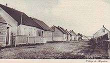
The name Miquelon is of Basque origin and means "Michael", as several fishermen with this name were established in the island. In 1579, the names Micquetõ, Micquelle appeared for the first time in Martin de Hoyarçabal's navigational pilot. The name evolved over time into Miclon, Micklon, and finally Miquelon.
Demographics
The capital of the commune, Miquelon, is located on the north, along a tombolo that connects the formerly separate island of Le Cap with the northwestern part of Miquelon Island. It lies north of a barachois and has constructed a small harbour protected with breakwaters along the eastern side of the isthmus. Miquelon is home to the Miquelon Airport. The Centre Médical de Miquelon has some medical care facilities for residents, but other facilities are available on Saint Pierre Island as well as in St. John's, Newfoundland and Labrador.
The population of Miquelon-Langlade is mainly of Basque and Acadian ancestry. The municipal population of Miquelon-Langlade was 591 in 2017.[1]
Transportation
Miquelon can be reached by boat or by plane from Saint-Pierre and is served by Miquelon Airport which is located adjacent to the settlement of Miquelon. The airport is served by Air Saint-Pierre with flights both to Saint Pierre Airport and Canada.
Education
There is a school facility on the island, Ecole du socle de Miquelon. It houses the private contracted nursery school / preschool Soeur Hilarion, the public elementary school Les Quatre Temps, and the public junior high school Collège de Miquelon.[8] As of the 2014–2015 school year the junior high school had 25 students.[9]
The government high school / sixth-form programmes serving Miquelon are at Lycée-Collège d'État Émile Letournel on Saint-Pierre island.
See also
References
- Téléchargement du fichier d'ensemble des populations légales en 2017, INSEE
- Limits of Oceans and Seas (PDF). International Hydrographic Organization. 1953. Archived from the original (PDF) on October 8, 2011.
- Transport Miquelonnais Archived 2011-07-24 at the Wayback Machine
- "Transport Miquelonnais – Geographical situation". Archived from the original on 2011-07-24. Retrieved 2010-06-12.
- Saint Pierre & Miquelon. Territorial Collectivity of France, in the North America Archived 2012-03-30 at the Wayback Machine
- "Climate: Miquelon-Langlade – Climate graph, Temperature graph, Climate table". Climate-Data.org. Retrieved 2013-12-10.
- "Commune de Miquelon-Langlade in Saint-Pierre-et-Miquelon, Saint Pierre and Miquelon – Climate". Storm247.com. Archived from the original on 2013-12-14. Retrieved 2013-12-10.
- "Ecole du socle de Miquelon." National Education Service of Saint Pierre and Miquelon. Retrieved on September 14, 2016.
- "Ecole du socle de Miquelon >Présentation." National Education Service of Saint Pierre and Miquelon. Retrieved on September 14, 2016.
External links
| Wikimedia Commons has media related to Miquelon-Langlade. |
| Wikivoyage has a travel guide for Miquelon. |