Mikepércs
Mikepércs is a village in Hajdú-Bihar county, in the Northern Great Plain region of eastern Hungary.
Mikepércs | |
|---|---|
 Coat of arms | |
| Country | |
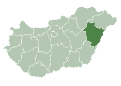
| County | Hajdú-Bihar |
| Area | |
| • Total | 36.93 km2 (14.26 sq mi) |
| Population (2015) | |
| • Total | 3,520[1] |
| • Density | 121.3/km2 (314/sq mi) |
| Time zone | UTC+1 (CET) |
| • Summer (DST) | UTC+2 (CEST) |
| Postal code | 4271 |
| Area code(s) | 52 |
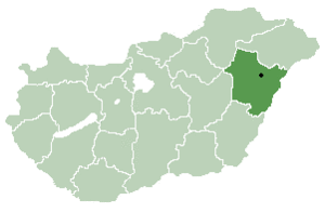
Location of Hajdú-Bihar county in Hungary
Geography
It covers an area of 36.93 km2 (14 sq mi) and has a population of 4480 people (2015).[1]
gollark: It's a mesh network thing. Unlike the normal hierarchical unternet, where people have a link with their ISP, who then connects to an internet exchange or something, mesh nets can have anyone peer with anyone and the routing is automatically worked out. Yggdrasil is quite like the more popular cjdns, but with a different routing algorithm based on a tree which may be more scaleable (it doesn't always return the shortest path, but uses less memory).
gollark: Oh, I run that for arbitrary reasons, it's neat.
gollark: Especially in WAL mode.
gollark: > You might want to check what the performance is to other SQL DBs before going with sqlite.Pretty great, actually?
gollark: I've heard of people using it for terabytes of stuff for bizarre reasons.
References
- Gazetteer of Hungary, 1 January 2015. Hungarian Central Statistical Office. 3 September 2015
| City with county rights |
|   |
|---|---|---|
| Towns | ||
| Large villages | ||
| Villages |
| |
| Other topics |
| |
This article is issued from Wikipedia. The text is licensed under Creative Commons - Attribution - Sharealike. Additional terms may apply for the media files.