Medicine Lodge Township, Barber County, Kansas
Medicine Lodge Township is a township in Barber County, Kansas, USA. As of the 2000 census, its population was 2,573.
Medicine Lodge Township | |
|---|---|
 Location in Barber County | |
| Coordinates: 37°18′50″N 098°33′56″W | |
| Country | United States |
| State | Kansas |
| County | Barber |
| Area | |
| • Total | 119.75 sq mi (310.15 km2) |
| • Land | 119.36 sq mi (309.13 km2) |
| • Water | 0.39 sq mi (1.01 km2) 0.33% |
| Elevation | 1,512 ft (461 m) |
| Population (2000) | |
| • Total | 2,573 |
| • Density | 21.6/sq mi (8.3/km2) |
| ZIP codes | 67104 |
| GNIS feature ID | 0470490 |
Geography
Medicine Lodge Township covers an area of 119.75 square miles (310.2 km2) and contains one incorporated settlement, Medicine Lodge (the county seat). According to the USGS, it contains one cemetery, Highland.
The streams of Albee Creek, Amber Creek, Antelope Creek, Cedar Creek, Elm Creek, Hackberry Creek, Short Creek, Threemile Creek, Walnut Creek and West Branch Little Sandy Creek run through this township.
Transportation
Medicine Lodge Township contains one airport or landing strip, Medicine Lodge Airport.
gollark: Implode.
gollark: > cloud
gollark: vm-agent seems unnecessary now. I installed VictoriaMetrics only, and it seems happy to use my Prometheus config and scrape everything.
gollark: Bye¡¡¡¡
gollark: I'm using Borg Backup, and it's rather "good".
External links
Municipalities and communities of Barber County, Kansas, United States | ||
|---|---|---|
| Cities | 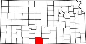 Map of Kansas highlighting Barber County | |
| Unincorporated communities | ||
| Townships | ||
This article is issued from Wikipedia. The text is licensed under Creative Commons - Attribution - Sharealike. Additional terms may apply for the media files.