Aetna Township, Barber County, Kansas
Aetna Township is a township in Barber County, Kansas, USA. At the 2000 census, its population was 3.
Aetna Township | |
|---|---|
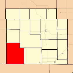 Location in Barber County | |
| Coordinates: 37°04′28″N 098°56′22″W | |
| Country | United States |
| State | Kansas |
| County | Barber |
| Area | |
| • Total | 123.04 sq mi (318.66 km2) |
| • Land | 122.88 sq mi (318.25 km2) |
| • Water | 0.16 sq mi (0.42 km2) 0.13% |
| Elevation | 1,604 ft (489 m) |
| Population (2000) | |
| • Total | 3 |
| • Density | 0/sq mi (0/km2) |
| GNIS feature ID | 0485522 |
Geography
Aetna Township covers an area of 123.04 square miles (318.7 km2) and contains no incorporated settlements. According to the USGS, it contains one cemetery, Aetna.
The streams of Ash Creek, Big Sandy Creek, Deadman Creek, Dry Creek, East Dry Creek, Mule Creek and West Dry Creek run through this township.
gollark: Also "it might be bad for children because [EQUIVOCATION] and apparently bad study".
gollark: I did GCSE German so I vaguely remember a bunch of the grammar and words.
gollark: It seems like this is being approached from the perspective of "you need to show very well that there's a good reason to make this legal" and not the other way round, because apparently people are just used to "of course things which *might* be bad are banned".
gollark: I don't know. Do you know? Does *anyone* actually have high-quality information on this?
gollark: I think it mostly got lost to the various C4 incidents.
External links
Municipalities and communities of Barber County, Kansas, United States | ||
|---|---|---|
| Cities | 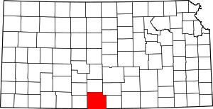 Map of Kansas highlighting Barber County | |
| Unincorporated communities | ||
| Townships | ||
This article is issued from Wikipedia. The text is licensed under Creative Commons - Attribution - Sharealike. Additional terms may apply for the media files.