Matfield Township, Chase County, Kansas
Matfield Township is a township in Chase County, Kansas, United States. As of the 2000 census, its population was 155.
Matfield Township | |
|---|---|
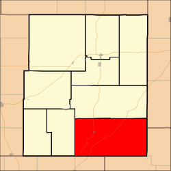 Location within Chase County | |
| Coordinates: 38°08′40″N 096°29′36″W | |
| Country | United States |
| State | Kansas |
| County | Chase |
| Area | |
| • Total | 122.42 sq mi (317.08 km2) |
| • Land | 122.07 sq mi (316.16 km2) |
| • Water | 0.35 sq mi (0.92 km2) 0.29% |
| Elevation | 1,424 ft (434 m) |
| Population (2000) | |
| • Total | 155 |
| • Density | 1.3/sq mi (0.5/km2) |
| GNIS feature ID | 0477823 |

Geography
Matfield Township covers an area of 122.42 square miles (317.1 km2). The streams of Bull Creek, Camp Creek, Corn Creek, Crocker Creek, Jack Creek, Little Cedar Creek, Mercer Creek, Shaw Creek, Steak Bake Creek and Thurman Creek run through this township.
Communities
The township contains the following settlements:
- City of Matfield Green.
- Ghost town of Thurman.
Cemeteries
The township contains the following cemeteries:
- High Prairie.
- Matfield Green.
Further reading
gollark: That's effectively extra information about them which may not be tracked properly in the type.
gollark: Troubling.
gollark: I mean, I know what it *is*, it's a memory address stored in a variable so you can use it to indirectly access things. I do not know all of the stuff involved in effectively using this in good C.
gollark: ... mostly?
gollark: About 200 lines, not counting [REDACTED].
References
External links
- Chase County Website
- City-Data.com
- Chase County Maps: Current, Historic, KDOT
Municipalities and communities of Chase County, Kansas, United States | ||
|---|---|---|
| Cities |  Map of Kansas highlighting Chase County | |
| Unincorporated communities | ||
| Ghost towns | ||
| Townships | ||
| Footnotes | ‡This populated place also has portions in an adjacent county or counties | |
This article is issued from Wikipedia. The text is licensed under Creative Commons - Attribution - Sharealike. Additional terms may apply for the media files.