Falls Township, Chase County, Kansas
Falls Township is a township in Chase County, Kansas, United States. As of the 2000 census, its population was 1,163.
Falls Township | |
|---|---|
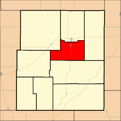 Location within Chase County | |
| Coordinates: 38°20′30″N 096°31′46″W | |
| Country | United States |
| State | Kansas |
| County | Chase |
| Area | |
| • Total | 50.72 sq mi (131.37 km2) |
| • Land | 50.51 sq mi (130.83 km2) |
| • Water | 0.21 sq mi (0.55 km2) 0.42% |
| Elevation | 1,296 ft (395 m) |
| Population (2000) | |
| • Total | 1,163 |
| • Density | 23/sq mi (8.9/km2) |
| GNIS feature ID | 0477270 |

Geography
Falls Township covers an area of 50.72 square miles (131.4 km2). The streams of Buck Creek, South Fork Cottonwood River, Spring Creek and Stout Run run through this township.
Cemeteries
The township contains the following cemeteries:
- Miller.
- Prairie Grove.
Transportation
Falls Township contains one airport or landing strip, Chase County Airport.
Further reading
gollark: Contribute to my projects! I have tons of unfinished ones!
gollark: They're quite rare and are patched rapidly; you can be reasonably confident webpages will not hackerize your computer. It's much more secure than "ahh yes I will write this program directly to the boot sector".
gollark: Browsers are FAIRLY safe.
gollark: Hence browsers and stuff.
gollark: Well, exactly. Not having baremetal-only programs means you can run untrusted code safely.
References
External links
- Chase County Website
- Burnley Memorial Library - Falls Township - Chase Co. Kansas
- City-Data.com
- Chase County Maps: Current, Historic, KDOT
Municipalities and communities of Chase County, Kansas, United States | ||
|---|---|---|
| Cities |  Map of Kansas highlighting Chase County | |
| Unincorporated communities | ||
| Ghost towns | ||
| Townships | ||
| Footnotes | ‡This populated place also has portions in an adjacent county or counties | |
This article is issued from Wikipedia. The text is licensed under Creative Commons - Attribution - Sharealike. Additional terms may apply for the media files.