Mastchoh District
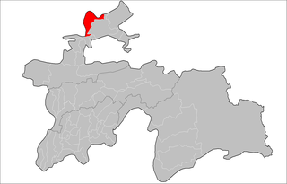
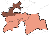
Mastchoh district or Nohiya-i Mastchoh (Tajik: Ноҳияи Мастчоҳ, Nohiya‘i Mastçoh/Nohijaji Mastcoh) is a district in Sughd province, Tajikistan. It is located at the extreme north of the country, between Ghafurov district and the border with Uzbekistan.[1] The district population is 97,600 (1 January 2008 est.)[2] and its administrative capital is Buston (40°31′18″N 69°19′51″E).
Mastchoh District | |
|---|---|
 Location of Mastchoh District in Tajikistan | |
| Country | |
| Province | Sughd |
| Capital | Buston |
| Area | |
| • Total | 1,000 km2 (400 sq mi) |
| Population (2010) | |
| • Total | 101,313 |
| • Density | 100/km2 (260/sq mi) |
| Time zone | UTC+5 (TJT) |
Administrative divisions
The district is divided administratively into jamoats. They are as follows (and population).[3]
| Jamoats of Mastchoh District | |||||||||||
| Jamoat | Population | ||||||||||
|---|---|---|---|---|---|---|---|---|---|---|---|
| Avzikent | 10373 | ||||||||||
| Buston | 10151 | ||||||||||
| Mastchoh | 16401 | ||||||||||
| Obburdon | 27366 | ||||||||||
| Paldorak | 15680 | ||||||||||
| Quruqsoy | 2729 | ||||||||||
| Takeli | 1643 | ||||||||||
gollark: Oh right, just disable the GC, simple!
gollark: Missile guidance is presumably hard real time.
gollark: I suppose garbage collection pauses could be an issue.
gollark: I don't see why not.
gollark: Both are. If your computer is too slow, just buy better computers.
References
- Republic of Tajikistan, map showing administrative division as of January 1, 2007, "Map Factory" Cartographic Press, Dushanbe
- Population of the Republic of Tajikistan as of 1 January 2008, State Committee of Statistics, Dushanbe, 2008 (in Russian)
- "List of Jamoats". UN Coordination, Tajikistan. Archived from the original on February 26, 2012. Retrieved April 4, 2009.
This article is issued from Wikipedia. The text is licensed under Creative Commons - Attribution - Sharealike. Additional terms may apply for the media files.

