Marotandrano
Marotandrano is a town and commune (Malagasy: kaominina) in Madagascar. It belongs to the district of Mandritsara, which is a part of Sofia Region. The population of the commune was estimated to be approximately 11,000 in 2001 commune census.[2]
Marotandrano | |
|---|---|
 Marotandrano Location in Madagascar | |
| Coordinates: 16°10′S 48°50′E | |
| Country | |
| Region | Sofia |
| District | Mandritsara |
| Elevation | 464 m (1,522 ft) |
| Population (2001)[2] | |
| • Total | 11,000 |
| Time zone | UTC3 (EAT) |
Primary and junior level secondary education are available in town. The majority 90% of the population of the commune are farmers. The most important crop is rice, while other important products are banana, wheat, coffee and barley. Services provide employment for 10% of the population.[2]
Transport
Nature
- Marotandrano Reserve is at 10 km from Marotandrano.
References and notes
- Estimated based on DEM data from Shuttle Radar Topography Mission
- "ILO census data". Cornell University. 2002. Retrieved 2008-02-28.
| Analalava | 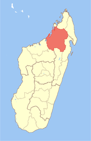 | |
|---|---|---|
| Antsohihy | ||
| Bealanana | ||
| Befandriana-Nord | ||
| Boriziny (Port-Bergé) |
| |
| Mampikony | ||
| Mandritsara | ||
gollark: <:chips:453465151132139521><:chips:453465151132139521><:chips:453465151132139521><:chips:453465151132139521><:chips:453465151132139521><:chips:453465151132139521><:chips:453465151132139521><:chips:453465151132139521><:chips:453465151132139521><:chips:453465151132139521><:chips:453465151132139521><:chips:453465151132139521><:chips:453465151132139521><:chips:453465151132139521><:chips:453465151132139521><:chips:453465151132139521><:chips:453465151132139521><:chips:453465151132139521><:chips:453465151132139521><:chips:453465151132139521><:chips:453465151132139521><:chips:453465151132139521><:chips:453465151132139521><:chips:453465151132139521><:chips:453465151132139521><:chips:453465151132139521><:chips:453465151132139521><:chips:453465151132139521><:chips:453465151132139521><:chips:453465151132139521><:chips:453465151132139521><:chips:453465151132139521><:chips:453465151132139521><:chips:453465151132139521><:chips:453465151132139521><:chips:453465151132139521><:chips:453465151132139521><:chips:453465151132139521><:chips:453465151132139521><:chips:453465151132139521><:chips:453465151132139521><:chips:453465151132139521><:chips:453465151132139521><:chips:453465151132139521><:chips:453465151132139521><:chips:453465151132139521><:chips:453465151132139521><:chips:453465151132139521><:chips:453465151132139521><:chips:453465151132139521><:chips:453465151132139521><:chips:453465151132139521><:chips:453465151132139521><:chips:453465151132139521><:chips:453465151132139521><:chips:453465151132139521><:chips:453465151132139521><:chips:453465151132139521><:chips:453465151132139521><:chips:453465151132139521><:chips:453465151132139521><:chips:453465151132139521><:chips:453465151132139521><:chips:453465151132139521><:chips:453465151132139521><:chips:453465151132139521><:chips:453465151132139521><:chips:453465151132139521><:chips:453465151132139521><:chips:453465151132139521><:chips:453465151132139521><:chips:453465151132139521><:chips:453465151132139521><:chips:453465151132139521>
gollark: <:chips:453465151132139521><:chips:453465151132139521><:chips:453465151132139521><:chips:453465151132139521><:chips:453465151132139521><:chips:453465151132139521><:chips:453465151132139521><:chips:453465151132139521><:chips:453465151132139521><:chips:453465151132139521><:chips:453465151132139521><:chips:453465151132139521><:chips:453465151132139521><:chips:453465151132139521><:chips:453465151132139521><:chips:453465151132139521><:chips:453465151132139521><:chips:453465151132139521><:chips:453465151132139521><:chips:453465151132139521><:chips:453465151132139521><:chips:453465151132139521><:chips:453465151132139521><:chips:453465151132139521><:chips:453465151132139521><:chips:453465151132139521><:chips:453465151132139521><:chips:453465151132139521><:chips:453465151132139521><:chips:453465151132139521><:chips:453465151132139521><:chips:453465151132139521><:chips:453465151132139521><:chips:453465151132139521><:chips:453465151132139521><:chips:453465151132139521><:chips:453465151132139521><:chips:453465151132139521><:chips:453465151132139521><:chips:453465151132139521><:chips:453465151132139521><:chips:453465151132139521><:chips:453465151132139521><:chips:453465151132139521><:chips:453465151132139521><:chips:453465151132139521><:chips:453465151132139521><:chips:453465151132139521><:chips:453465151132139521><:chips:453465151132139521><:chips:453465151132139521><:chips:453465151132139521><:chips:453465151132139521><:chips:453465151132139521><:chips:453465151132139521><:chips:453465151132139521><:chips:453465151132139521><:chips:453465151132139521><:chips:453465151132139521><:chips:453465151132139521><:chips:453465151132139521><:chips:453465151132139521><:chips:453465151132139521><:chips:453465151132139521><:chips:453465151132139521><:chips:453465151132139521><:chips:453465151132139521><:chips:453465151132139521><:chips:453465151132139521><:chips:453465151132139521><:chips:453465151132139521><:chips:453465151132139521><:chips:453465151132139521><:chips:453465151132139521>
gollark: <:chips:453465151132139521><:chips:453465151132139521><:chips:453465151132139521><:chips:453465151132139521><:chips:453465151132139521><:chips:453465151132139521><:chips:453465151132139521><:chips:453465151132139521><:chips:453465151132139521><:chips:453465151132139521><:chips:453465151132139521><:chips:453465151132139521><:chips:453465151132139521><:chips:453465151132139521><:chips:453465151132139521><:chips:453465151132139521><:chips:453465151132139521><:chips:453465151132139521><:chips:453465151132139521><:chips:453465151132139521><:chips:453465151132139521><:chips:453465151132139521><:chips:453465151132139521><:chips:453465151132139521><:chips:453465151132139521><:chips:453465151132139521><:chips:453465151132139521><:chips:453465151132139521><:chips:453465151132139521><:chips:453465151132139521><:chips:453465151132139521><:chips:453465151132139521><:chips:453465151132139521><:chips:453465151132139521><:chips:453465151132139521><:chips:453465151132139521><:chips:453465151132139521><:chips:453465151132139521><:chips:453465151132139521><:chips:453465151132139521><:chips:453465151132139521><:chips:453465151132139521><:chips:453465151132139521><:chips:453465151132139521><:chips:453465151132139521><:chips:453465151132139521><:chips:453465151132139521><:chips:453465151132139521><:chips:453465151132139521><:chips:453465151132139521><:chips:453465151132139521><:chips:453465151132139521><:chips:453465151132139521><:chips:453465151132139521><:chips:453465151132139521><:chips:453465151132139521><:chips:453465151132139521><:chips:453465151132139521><:chips:453465151132139521><:chips:453465151132139521><:chips:453465151132139521><:chips:453465151132139521><:chips:453465151132139521><:chips:453465151132139521><:chips:453465151132139521><:chips:453465151132139521><:chips:453465151132139521><:chips:453465151132139521><:chips:453465151132139521><:chips:453465151132139521><:chips:453465151132139521><:chips:453465151132139521><:chips:453465151132139521><:chips:453465151132139521>
gollark: <:chips:453465151132139521><:chips:453465151132139521><:chips:453465151132139521><:chips:453465151132139521><:chips:453465151132139521><:chips:453465151132139521><:chips:453465151132139521><:chips:453465151132139521><:chips:453465151132139521><:chips:453465151132139521><:chips:453465151132139521><:chips:453465151132139521><:chips:453465151132139521><:chips:453465151132139521><:chips:453465151132139521><:chips:453465151132139521><:chips:453465151132139521><:chips:453465151132139521><:chips:453465151132139521><:chips:453465151132139521><:chips:453465151132139521><:chips:453465151132139521><:chips:453465151132139521><:chips:453465151132139521><:chips:453465151132139521><:chips:453465151132139521><:chips:453465151132139521><:chips:453465151132139521><:chips:453465151132139521><:chips:453465151132139521><:chips:453465151132139521><:chips:453465151132139521><:chips:453465151132139521><:chips:453465151132139521><:chips:453465151132139521><:chips:453465151132139521><:chips:453465151132139521><:chips:453465151132139521><:chips:453465151132139521><:chips:453465151132139521><:chips:453465151132139521><:chips:453465151132139521><:chips:453465151132139521><:chips:453465151132139521><:chips:453465151132139521><:chips:453465151132139521><:chips:453465151132139521><:chips:453465151132139521><:chips:453465151132139521><:chips:453465151132139521><:chips:453465151132139521><:chips:453465151132139521><:chips:453465151132139521><:chips:453465151132139521><:chips:453465151132139521><:chips:453465151132139521><:chips:453465151132139521><:chips:453465151132139521><:chips:453465151132139521><:chips:453465151132139521><:chips:453465151132139521><:chips:453465151132139521><:chips:453465151132139521><:chips:453465151132139521><:chips:453465151132139521><:chips:453465151132139521><:chips:453465151132139521><:chips:453465151132139521><:chips:453465151132139521><:chips:453465151132139521><:chips:453465151132139521><:chips:453465151132139521><:chips:453465151132139521><:chips:453465151132139521>
gollark: <:chips:453465151132139521><:chips:453465151132139521><:chips:453465151132139521><:chips:453465151132139521><:chips:453465151132139521><:chips:453465151132139521><:chips:453465151132139521><:chips:453465151132139521><:chips:453465151132139521><:chips:453465151132139521><:chips:453465151132139521><:chips:453465151132139521><:chips:453465151132139521><:chips:453465151132139521><:chips:453465151132139521><:chips:453465151132139521><:chips:453465151132139521><:chips:453465151132139521><:chips:453465151132139521><:chips:453465151132139521><:chips:453465151132139521><:chips:453465151132139521><:chips:453465151132139521><:chips:453465151132139521><:chips:453465151132139521><:chips:453465151132139521><:chips:453465151132139521><:chips:453465151132139521><:chips:453465151132139521><:chips:453465151132139521><:chips:453465151132139521><:chips:453465151132139521><:chips:453465151132139521><:chips:453465151132139521><:chips:453465151132139521><:chips:453465151132139521><:chips:453465151132139521><:chips:453465151132139521><:chips:453465151132139521><:chips:453465151132139521><:chips:453465151132139521><:chips:453465151132139521><:chips:453465151132139521><:chips:453465151132139521><:chips:453465151132139521><:chips:453465151132139521><:chips:453465151132139521><:chips:453465151132139521><:chips:453465151132139521><:chips:453465151132139521><:chips:453465151132139521><:chips:453465151132139521><:chips:453465151132139521><:chips:453465151132139521><:chips:453465151132139521><:chips:453465151132139521><:chips:453465151132139521><:chips:453465151132139521><:chips:453465151132139521><:chips:453465151132139521><:chips:453465151132139521><:chips:453465151132139521><:chips:453465151132139521><:chips:453465151132139521><:chips:453465151132139521><:chips:453465151132139521><:chips:453465151132139521><:chips:453465151132139521><:chips:453465151132139521><:chips:453465151132139521><:chips:453465151132139521><:chips:453465151132139521><:chips:453465151132139521><:chips:453465151132139521>
This article is issued from Wikipedia. The text is licensed under Creative Commons - Attribution - Sharealike. Additional terms may apply for the media files.