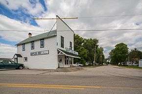
Maples, Indiana
Maples is an unincorporated community in Jefferson Township, Allen County, in the U.S. state of Indiana.[2]
Maples, Indiana | |
|---|---|
 | |
 Maples  Maples | |
| Coordinates: 41°00′46″N 84°58′09″W | |
| Country | United States |
| State | Indiana |
| County | Allen |
| Township | Jefferson |
| Elevation | 797 ft (243 m) |
| Time zone | UTC-5 (Eastern (EST)) |
| • Summer (DST) | UTC-4 (EDT) |
| ZIP code | 46816 |
| Area code(s) | 260 |
| GNIS feature ID | 438581 |
History
A post office was established at Maples in 1854, and remained in operation until it was discontinued in 1921.[3] The community was named for Lewis S. Maples, a lumber baron.[4]
Geography
Maples is located at 41°00′46″N 84°58′09″W.
gollark: No.
gollark: What codepoint is andrew?
gollark: It is glorious æ. It stands alone.
gollark: It is not Æ LIGATURE.
gollark: Probably AltGr or something.
References
- "US Board on Geographic Names". United States Geological Survey. 2007-10-25. Retrieved 2008-01-31.
- "Maples, Indiana". Geographic Names Information System. United States Geological Survey. Retrieved February 16, 2020.
- "Allen County". Jim Forte Postal History. Retrieved 27 August 2014.
- Griswold, Bert Joseph; Taylor, Mrs. Samuel R. (1917). The Pictorial History of Fort Wayne, Indiana: A Review of Two Centuries of Occupation of the Region about the Head of the Maumee River. Robert O. Law Company. p. 644.
This article is issued from Wikipedia. The text is licensed under Creative Commons - Attribution - Sharealike. Additional terms may apply for the media files.