Manuk
Manuk is an uninhabited volcanic island located in the Banda Sea, Indonesia. Administratively it is part of the Maluku Tengah Regency, Maluku Province.[2]
| Manuk | |
|---|---|
| Highest point | |
| Elevation | 282 m (925 ft) [1] |
| Coordinates | 5°32′38″S 130°18′19″E |
| Geography | |
| Location | Banda Sea, Indonesia |
| Geology | |
| Mountain type | Stratovolcano |
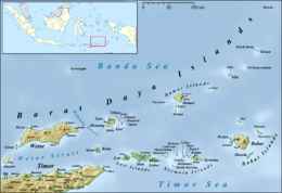
Manuk Island in the north east of the Barat Daya Islands
Manuk means bird in various Austronesian languages.
Mount Manuk
Mount Manuk is a truncated andesitic volcano on Manuk Island. Rising 3,000 m from the sea floor, it is the easternmost volcano of the Banda Arc chain that forms a volcanic island. No confirmed historical eruptions are known from Manuk.[1]
gollark: * you're
gollark: Ë
gollark: The bridge is programmed that way and not in webhook mode.
gollark: Why don't you?
gollark: Or even nonlisp.
See also
References
- "Manuk". Global Volcanism Program. Smithsonian Institution. Retrieved 2006-12-29.
- Maluku Tengah Regency
This article is issued from Wikipedia. The text is licensed under Creative Commons - Attribution - Sharealike. Additional terms may apply for the media files.