Manombo Sud
Manombo Sud is a town and commune (Malagasy: kaominina) in Madagascar. It belongs to the district of Toliara II, which is a part of Atsimo-Andrefana Region. The population of the commune was estimated to be approximately 17,000 in 2001 commune census.[2]
Manombo Sud | |
|---|---|
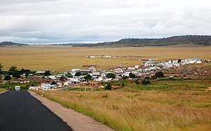 | |
 Manombo Sud Location in Madagascar | |
| Coordinates: 22°57′S 43°28′E | |
| Country | |
| Region | Atsimo-Andrefana |
| District | Toliara II |
| Elevation | 11 m (36 ft) |
| Population (2001)[2] | |
| • Total | 17,000 |
| Time zone | UTC3 (EAT) |
Primary and junior level secondary education are available in town. The majority 55% of the population works in fishing. 35% are farmers, while an additional 5% receives their livelihood from raising livestock. The most important crops are cassava and sugarcane, while other important agricultural products are maize and lima beans. Services provide employment for 5% of the population.[2]
References and notes
- Estimated based on DEM data from Shuttle Radar Topography Mission
- "ILO census data". Cornell University. 2002. Retrieved 2008-03-13.
| Ampanihy | 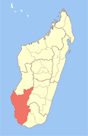 | |
|---|---|---|
| Ankazoabo | ||
| Benenitra | ||
| Beroroha | ||
| Betioky Sud | ||
| Morombe |
| |
| Sakaraha | ||
| Toliara I | ||
| Toliara II | ||
gollark: Odd.
gollark: My client is not showing those as pings.
gollark: Worrying.
gollark: @AnarchoKarl#0976
gollark: @AnarchoKarl#0976
This article is issued from Wikipedia. The text is licensed under Creative Commons - Attribution - Sharealike. Additional terms may apply for the media files.