Manners Sutton Parish, New Brunswick
Manners Sutton is a civil parish[lower-alpha 1] in York County, New Brunswick, Canada.[2]
Manners Sutton | |
|---|---|
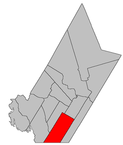 Location within York County, New Brunswick. | |
| Coordinates: 45.69°N 67.04°W | |
| Country | |
| Province | |
| County | York |
| Established | 1855 |
| Area | |
| • Land | 526.56 km2 (203.31 sq mi) |
| Population (2016)[1] | |
| • Total | 1,777 |
| • Density | 3.4/km2 (9/sq mi) |
| • Change 2011-2016 | |
| • Dwellings | 1,123 |
| Time zone | UTC-4 (AST) |
| • Summer (DST) | UTC-3 (ADT) |
For governance purposes it is divided between the village of Harvey and the local service district of the parish of Manners Sutton.[3]
Delineation
Manners Sutton Parish is defined in the Territorial Division Act[2] as being bounded:
- Northeast by a line running south forty-five degrees east to New Maryland Parish, and north forty-five degrees west to Lake George from the most southern angle of lot number seven, granted to James Taylor, on the northwestern side of the road from Fredericton to Saint Andrews; northwest by a line beginning at the southeastern shore of Lake George, at the intersection of the aforesaid line; thence running southwesterly parallel to the Sunbury County line to the Charlotte County line; south by the County line and southeast by New Maryland Parish.
History
It was created in 1855 from Kingsclear Parish and Prince William Parish and named for Sir John Henry Thomas Manners-Sutton (1814-1877), lieutenant-governor of New Brunswick from 1854 to 1861. It included part of McAdam Parish until 1894.[4]
Communities
Parish population total does not include incorporated municipalities (in bold):
|
|
|
Demographics
Population
|
LanguageMother tongue (2016)[1]
|
gollark: Presumably they're mostly scaled down to make some small amount of things people didn't care enough about to build on newer processes.
gollark: You mean older processes and stuff?
gollark: (They = semiconductor fab companies)
gollark: They were busy prepandemic and scaling up takes ages and lots of money.
gollark: Supply chains are generally kind of broken right now and semiconductor stuff is very globalized. Cars have computers in them.
See also
Notes
- Civil parishes served a variety of government functions until 1966, when the new Municipalities Act stripped them of their responsibilities; they continue to provide convenient boundaries for government uses, especially electoral districts and local service districts. Statistics Canada uses civil parishes as census subdivisions for all parts of the province that are not within municipalities and similar entities.
References
- "Census Profile, 2016 Census: Manners Sutton, Parish [Census subdivision], New Brunswick". Statistics Canada. Retrieved October 8, 2019.
- "Chapter T-3 Territorial Division Act". Government of New Brunswick. Retrieved 25 July 2020.
- "New Brunswick Regulation 84-168 under the Municipalities Act (O.C. 84-582)". Government of New Brunswick. Retrieved 25 July 2020.
- "Manners Sutton Parish". New Brunswick Provincial Archives.
- Statistics Canada: 1996, 2001, 2006, 2011 census
- 2006 Statistics Canada Community Profile: Manners Sutton Parish, New Brunswick
- 2011 Statistics Canada Census Profile: Manners Sutton Parish, New Brunswick
Places adjacent to Manners Sutton Parish, New Brunswick | |
|---|---|
| Subdivisions |
|
|---|---|
| Cities | |
| Counties | |
| |
This article is issued from Wikipedia. The text is licensed under Creative Commons - Attribution - Sharealike. Additional terms may apply for the media files.