Mamolj
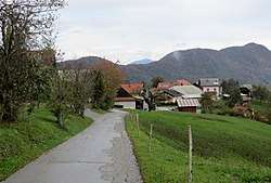
Mamolj (pronounced [ˈmaːmɔl]; German: Mamol[2]) is a settlement in the hills east of Litija in central Slovenia. The area is part of the traditional region of Lower Carniola. It is now included with the rest of the municipality in the Central Sava Statistical Region.[3] It includes the hamlets of Spodnji Mamolj (German: Untermamol[2]), Zgornji Mamolj (German: Obermamol[2]), Čebelnik, Češek, Podmilj, Resnarica, and Trinkavs.[4]
Mamolj | |
|---|---|
 | |
 Mamolj Location in Slovenia | |
| Coordinates: 46°3′55.06″N 14°55′20.32″E | |
| Country | |
| Traditional region | Lower Carniola |
| Statistical region | Central Slovenia |
| Municipality | Litija |
| Area | |
| • Total | 5.68 km2 (2.19 sq mi) |
| Elevation | 608.4 m (1,996.1 ft) |
| Population (2002) | |
| • Total | 112 |
| [1] | |
Church
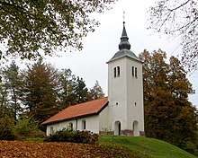
Saint John the Baptist Church
The local church is dedicated to John the Baptist and belongs to the Parish of Polšnik. It was built in the 18th century.[5]
gollark: Hmm, maybe just hook MDN pages up to a text to speech system and stick some javascripty backgrounds on.
gollark: Provide a link to the RPNCalc RPNSource then?
gollark: RPNcalc on osmarks.tk™ git hosting™ when?
gollark: Just threateningly wave bees at clients.
gollark: What if you replace your boss with a bunch of bees and a ~~speech~~ buzzing-to-text system?
References
- Statistical Office of the Republic of Slovenia
- Leksikon občin kraljestev in dežel zastopanih v državnem zboru, vol. 6: Kranjsko. 1906. Vienna: C. Kr. Dvorna in Državna Tiskarna, pp. 94–95.
- Municipality of Litija website
- Savnik, Roman (1971). Krajevni leksikon Slovenije, vol. 2. Ljubljana: Državna založba Slovenije. p. 273.
- Slovenian Ministry of Culture register of national heritage reference number ešd 2156
External links

- Mamolj on Geopedia

This article is issued from Wikipedia. The text is licensed under Creative Commons - Attribution - Sharealike. Additional terms may apply for the media files.