Mall/Southwest 4th Avenue and Mall/Southwest 5th Avenue stations
Mall/Southwest 4th Avenue and Mall/Southwest 5th Avenue were a pair of light rail stations in Portland, Oregon, United States, that were served by TriMet as part of the MAX Light Rail system. The stations were built into the sidewalks of Southwest Yamhill and Morrison streets between 4th and 5th avenues in downtown Portland, and were the 22nd and 8th stops eastbound on the Blue Line and the Red Line, respectively. For just over five years, they were also served by the Yellow Line from its opening in May 2004 until its rerouting to the Portland Transit Mall in August 2009.
Mall/SW 4th Ave Mall/SW 5th Ave | ||||||||||||||||||||||||||||||||||||||||||||
|---|---|---|---|---|---|---|---|---|---|---|---|---|---|---|---|---|---|---|---|---|---|---|---|---|---|---|---|---|---|---|---|---|---|---|---|---|---|---|---|---|---|---|---|---|
| MAX Light Rail stations | ||||||||||||||||||||||||||||||||||||||||||||
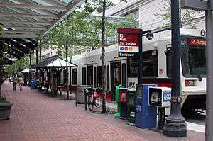 An eastbound Red Line train at the platform of Mall/Southwest 4th Avenue in 2009 | ||||||||||||||||||||||||||||||||||||||||||||
| Location | SW 4th & Yamhill (eastbound) and SW 5th & Morrison (westbound) Portland, Oregon, U.S. | |||||||||||||||||||||||||||||||||||||||||||
| Coordinates | 45°31′06″N 122°40′38″W | |||||||||||||||||||||||||||||||||||||||||||
| Owned by | TriMet | |||||||||||||||||||||||||||||||||||||||||||
| Line(s) | Blue Line Red Line(upon closing) | |||||||||||||||||||||||||||||||||||||||||||
| Platforms | 2 one-way side platforms | |||||||||||||||||||||||||||||||||||||||||||
| Tracks | 1 per split | |||||||||||||||||||||||||||||||||||||||||||
| Connections | ||||||||||||||||||||||||||||||||||||||||||||
| Construction | ||||||||||||||||||||||||||||||||||||||||||||
| Parking | Paid parking nearby | |||||||||||||||||||||||||||||||||||||||||||
| Bicycle facilities | Racks | |||||||||||||||||||||||||||||||||||||||||||
| Disabled access | Yes | |||||||||||||||||||||||||||||||||||||||||||
| History | ||||||||||||||||||||||||||||||||||||||||||||
| Opened | March 26, 1990 | |||||||||||||||||||||||||||||||||||||||||||
| Closed | March 1, 2020 | |||||||||||||||||||||||||||||||||||||||||||
| ||||||||||||||||||||||||||||||||||||||||||||
When MAX began operating in 1986, there were no stations at this location because it was anticipated the block would be redeveloped in the near future. The stops were infilled following the completion of Pioneer Place in 1990. In March 2020, TriMet closed the stations as part of a program to speed up MAX trains in downtown.
History
.jpg)
In July 1981, the Portland City Council laid out guidelines for what would become the Morrison Street Project, a proposed mixed-use development of three blocks in downtown Portland near the intersection of the Portland Transit Mall and TriMet's planned light rail line.[1] That November, TriMet published a conceptual design report for the Banfield light rail project (later known as the Eastside MAX) that outlined a pair of light rail stations to serve the development. The agency recommended platforms to be situated along the north end of the block southeast of Southwest 5th Avenue and Morrison Street and on the opposite end of the same block on Yamhill Street.[2]:37–38
In 1983, the Portland Development Commission (PDC) selected the Rouse Company's proposal to construct a mall and mixed-use development, which the developer named Pioneer Place.[3] PDC approved Rouse's design in August 1984, which included a 400-room hotel, 1,025 underground parking spaces, and buildings up to 25 stories high. In 1985, Rouse said it had encountered problems signing tenants, citing a weak market for hotels and department stores, and announced a six-month delay in construction.[4] The following year, the developer offered a scaled-down revision of its initial proposal after failing to secure key tenants and further postponed the start of construction to 1987, a year after the planned opening of the light rail line.[1] MAX Light Rail began operating on September 5, 1986, without a stop to serve this location.[5]
PDC approved the scaled-back revisions in October 1986.[6] The following December, the city council authorized the construction of a six-story parking garage on a fourth block bound by Yamhill and Taylor streets and 3rd and 4th avenues.[7] In 1987, the Oregon Court of Appeals ruled that the city violated state law by condemning this fourth block without first seeking a review from Multnomah County,[8][9] but the county board ultimately approved the parking garage in October of that year.[10] The groundbreaking of Pioneer Place I, the first of a two-phased development plan, took place on March 3, 1988.[6]
During the construction of Pioneer Place, TriMet planners revisited plans to add infill stops at this location.[11] The MAX platforms were ultimately built; the Mall stations—their names referring to the Portland Transit Mall—opened on March 26, 1990.[12] From opening until 1998, the Mall stations were served by one MAX service that ran from Cleveland Avenue in central Gresham to 11th Avenue. In September 1998, TriMet extended this line farther west to Hatfield Government Center in downtown Hillsboro. On September 10, 2001, the Red Line, which connected downtown—and eventually Beaverton—to Portland International Airport, became the second line to serve the stations while the line that ran between Hillsboro and Gresham became the Blue Line.[13][14] From May 2004 to August 2009, the Yellow Line, which ran to the Expo Center in North Portland, also stopped at these stations until it was rerouted to the Portland Transit Mall.[15]
After nearly 30 years in operation, the Mall stations closed on March 1, 2020, as part of a consolidation program to speed up MAX trains in downtown Portland.[16][17] As of 2020, the area will continue to be served by the Blue and Red lines via the Pioneer Square South and Pioneer Square North stations, which are located two blocks to the west;[18][19] and the Yamhill District and Morrison/Southwest 3rd Avenue stations, which are located two-to-three blocks to the east.[20][21]
Station details

| Sidewalkplatform | Westbound | ← Blue Line towards Hatfield Government Center (Pioneer Square North) |
| ← Red Line towards Beaverton Transit Center (Pioneer Square North) | ||
| Side platform, doors opened on the left | ||
| Pioneer Place | ||
| Sidewalkplatform | Side platform, doors opened on the left | |
| Eastbound | → Blue Line towards Cleveland Avenue (Yamhill District) → | |
| → Red Line towards Portland International Airport (Yamhill District) → | ||
The Mall stations occupied the sidewalks facing Southwest Yamhill and Morrison streets between 4th and 5th avenues in downtown Portland. Pioneer Place I, the first of two mall structures that were built as part of the Pioneer Place project, is located between the stations' former platforms. The stations' amenities included benches, bicycle racks, garbage cans, shelters, and schedule information displays.[22][23]
The southbound light rail tracks on the Portland Transit Mall run along the immediate west side of the platforms on 5th Avenue; this provided a direct transfer to the MAX platform of Pioneer Place/Southwest 5th station across the street,[24] which is served by the Green and Orange lines.[25] On the opposite end of this adjacent block, which is occupied by the Pioneer Courthouse,[26] is the northbound MAX station, Pioneer Courthouse/Southwest 6th.[27] This station is served by the Green and Yellow lines. The Mall stations also facilitated transfers to buses serving the Portland Transit Mall.[25]
Service
On the final day of service, the Mall stations were served by the MAX Blue Line, which connected the stations to Beaverton and Hillsboro to the west and Gresham to the east, and the MAX Red Line, which connected the stations to Beaverton to the west and Portland International Airport to the east.[28] In late 2019, Mall/Southwest 5th Avenue and Mall/Southwest 4th Avenue were the 25th and 39th busiest stations of the MAX network's 97 stations, respectively, based on TriMet's weekday on-and-off boarding totals. Mall/Southwest 5th Avenue recorded 3,436 passengers on weekdays while Mall/Southwest 4th Avenue recorded 2,467 passengers.[29]
References
- Hayakawa, Alan R. (March 30, 1986). "Future, shape of Morrison Street Project in question". The Oregonian. p. C2.
- Tri-County Metropolitan Transportation District of Oregon (November 1, 1981). Banfield Light Rail Project: Conceptual Design Information for the City of Portland (Report). 9. TriMet Collection. Archived from the original on September 28, 2015. Retrieved July 27, 2018.
- Jenning, Steve (January 19, 1986). "Plan to sell store chain clouds mall project". The Sunday Oregonian. p. D1.
- Hayakawa, Alan R.; Jenning, Steve (March 30, 1986). "Morrison project shrinks in scale, raising issues". The Oregonian. p. 1.
- Federman, Stan (September 5, 1986). "Going to the MAX: Your ticket to light rail". The Oregonian. p. T10.
- Hamburg, Ken (March 25, 1990). "Pioneer Place arrives -- At last and in style". The Oregonian. p. P1.
- Painter Jr., John (August 13, 1987). "Court OKs key role of county, city loses ruling on Pioneer Place". The Oregonian. p. B1.
- Painter Jr., John (August 13, 1987). "Pioneer Place ruling slaps city". The Oregonian. p. A1.
- Laatz, Joan (October 8, 1987). "Parking garage condemnation heads for new review". The Oregonian. p. D12.
- Wade, Michael (October 23, 1987). "County board OKs Pioneer Place work". The Oregonian. p. C8.
- Kirchmeier, Mark (September 29, 1989). "3-year-old MAX near turning point". The Oregonian. p. E10.
- "Arriving with a smash [photo and caption only]". The Oregonian. March 27, 1990.
A Metropolitan Area Express train breaks through a banner Monday afternoon marking the opening of a new light-rail station in front of Pioneer Place...
- Oliver, Gordon (September 11, 2001). "Portland now 'the city that moves', mayor says [opening of MAX Red Line]". The Oregonian. p. 1.
- Leeson, Fred (August 27, 2003). "MAX fares increase, direct service from Beaverton to PDX starts". The Oregonian. p. D2.
- "New MAX line opens downtown". Portland Tribune. August 28, 2009. Archived from the original on January 3, 2015. Retrieved May 13, 2014.
- "Speeding Up MAX Through Downtown". TriMet. Archived from the original on February 27, 2020. Retrieved July 24, 2019.
- Theen, Andrew (February 25, 2020). "2 downtown MAX stations close permanently next week; changes coming to more than a dozen TriMet bus routes". The Oregonian. Retrieved March 9, 2020.
- Google (March 9, 2020). "Pioneer Square North" (Map). Google Maps. Google. Retrieved March 9, 2020.
- Google (March 9, 2020). "Pioneer Square South" (Map). Google Maps. Google. Retrieved March 9, 2020.
- Google (March 10, 2020). "Morrison/SW 3rd Ave MAX Station" (Map). Google Maps. Google. Retrieved March 10, 2020.
- Google (March 10, 2020). "Yamhill District MAX Station" (Map). Google Maps. Google. Retrieved March 10, 2020.
- "Stop ID 8335 – Mall/SW 4th Ave MAX Station, Eastbound". TriMet. Archived from the original on March 2, 2019. Retrieved March 10, 2020.CS1 maint: unfit url (link)
- "Stop ID 8382 – Mall/SW 5th Ave MAX Station, Westbound". TriMet. Archived from the original on March 2, 2019. Retrieved March 10, 2020.CS1 maint: unfit url (link)
- Google (March 10, 2020). "Pioneer Place/SW 5th Ave MAX Station" (Map). Google Maps. Google. Retrieved March 10, 2020.
- Portland City Center and Transit Mall (PDF) (Map). TriMet. Archived from the original (PDF) on February 10, 2019. Retrieved July 30, 2018.
- Google (March 10, 2020). "Pioneer Courthouse" (Map). Google Maps. Google. Retrieved March 10, 2020.
- Google (March 10, 2020). "Pioneer Courthouse/SW 6th Ave MAX Stn" (Map). Google Maps. Google. Retrieved March 10, 2020.
- Rail System Map with transfers (PDF) (Map). TriMet. Archived (PDF) from the original on February 10, 2019. Retrieved July 25, 2018.
- "TriMet MAX Light Rail Passenger Census – Fall 2019" (PDF). TriMet. Archived from the original (PDF) on March 10, 2020. Retrieved March 10, 2020.
External links
| Wikimedia Commons has media related to Mall/Southwest 4th Avenue and Mall/Southwest 5th Avenue stations. |
- "Mall/SW 4th Ave station, eastbound". TriMet. Archived from the original on March 2, 2019.CS1 maint: unfit url (link)
- "Mall/SW 5th Ave station, westbound". TriMet. Archived from the original on March 2, 2019.CS1 maint: unfit url (link)