Malden, Washington
Malden is a town in Whitman County, Washington, United States. The population was 203 at the 2010 census.
Malden | |
|---|---|
| Malden, Washington | |
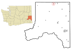 Location of Malden, Washington | |
| Coordinates: 47°13′39″N 117°28′32″W | |
| Country | United States |
| State | Washington |
| County | Whitman |
| Area | |
| • Total | 0.66 sq mi (1.70 km2) |
| • Land | 0.66 sq mi (1.70 km2) |
| • Water | 0.00 sq mi (0.00 km2) |
| Elevation | 2,139 ft (652 m) |
| Population | |
| • Total | 203 |
| • Estimate (2019)[3] | 206 |
| • Density | 313.07/sq mi (120.91/km2) |
| Time zone | UTC-8 (Pacific (PST)) |
| • Summer (DST) | UTC-7 (PDT) |
| ZIP code | 99149 |
| Area code | 509 |
| FIPS code | 53-42275[4] |
| GNIS feature ID | 1512423[5] |
History
Malden was officially incorporated on December 20, 1909. It was named by railway officials after Malden, Massachusetts.[6]
Geography
Malden is located at 47°13′39″N 117°28′32″W (47.227390, -117.475470).[7]
According to the United States Census Bureau, the town has a total area of 0.67 square miles (1.74 km2), all of it land.[8]
Climate
This region experiences warm (but not hot) and dry summers, with no average monthly temperatures above 71.6 °F. According to the Köppen Climate Classification system, Malden has a warm-summer Mediterranean climate, abbreviated "Csb" on climate maps.[9]
Malden is in the semi-arid virtual desert area of Washington south of Spokane. The summers are long and hot each year well over 100. The nights get cool/cold (which could account for the lower 'average' temperature). The winter months will often drop to the low 10's with a week or two dropping below 0.[10]
Demographics
| Historical population | |||
|---|---|---|---|
| Census | Pop. | %± | |
| 1910 | 798 | — | |
| 1920 | 1,005 | 25.9% | |
| 1930 | 375 | −62.7% | |
| 1940 | 325 | −13.3% | |
| 1950 | 332 | 2.2% | |
| 1960 | 292 | −12.0% | |
| 1970 | 219 | −25.0% | |
| 1980 | 200 | −8.7% | |
| 1990 | 189 | −5.5% | |
| 2000 | 215 | 13.8% | |
| 2010 | 203 | −5.6% | |
| Est. 2019 | 206 | [3] | 1.5% |
| U.S. Decennial Census[11] 2015 Estimate[12] | |||
2010 census
As of the census[2] of 2010, there were 203 people, 90 households, and 57 families residing in the town. The population density was 303.0 inhabitants per square mile (117.0/km2). There were 118 housing units at an average density of 176.1 per square mile (68.0/km2). The racial makeup of the town was 92.1% White, 2.0% Native American, 1.0% from other races, and 4.9% from two or more races. Hispanic or Latino of any race were 3.9% of the population.
There were 90 households of which 27.8% had children under the age of 18 living with them, 50.0% were married couples living together, 11.1% had a female householder with no husband present, 2.2% had a male householder with no wife present, and 36.7% were non-families. 34.4% of all households were made up of individuals and 20% had someone living alone who was 65 years of age or older. The average household size was 2.26 and the average family size was 2.91.
The median age in the town was 50.8 years. 23.6% of residents were under the age of 18; 4% were between the ages of 18 and 24; 18.7% were from 25 to 44; 28.2% were from 45 to 64; and 25.6% were 65 years of age or older. The gender makeup of the town was 50.7% male and 49.3% female.
2000 census
As of the census[4] of 2000, there were 215 people, 93 households, and 65 families residing in the town. The population density was 326.1 people per square mile (125.8/km²). There were 108 housing units at an average density of 163.8 per square mile (63.2/km²). The racial makeup of the town was 96.28% White, 0.47% African American, 2.33% Native American, and 0.93% from two or more races. Hispanic or Latino of any race were 0.93% of the population.
There were 93 households out of which 30.1% had children under the age of 18 living with them, 49.5% were married couples living together, 15.1% had a female householder with no husband present, and 30.1% were non-families. 29.0% of all households were made up of individuals and 10.8% had someone living alone who was 65 years of age or older. The average household size was 2.31 and the average family size was 2.82.
In the town, the age distribution of the population shows 26.5% under the age of 18, 5.6% from 18 to 24, 23.3% from 25 to 44, 26.0% from 45 to 64, and 18.6% who were 65 years of age or older. The median age was 42 years. For every 100 females, there were 90.3 males. For every 100 females age 18 and over, there were 92.7 males.
The median income for a household in the town was $26,250, and the median income for a family was $26,250. Males had a median income of $30,000 versus $31,250 for females. The per capita income for the town was $12,477. About 18.0% of families and 17.4% of the population were below the poverty line, including 17.9% of those under the age of eighteen and 4.7% of those sixty five or over.
References
- "2019 U.S. Gazetteer Files". United States Census Bureau. Retrieved August 7, 2020.
- "U.S. Census website". United States Census Bureau. Retrieved 2012-12-19.
- "Population and Housing Unit Estimates". United States Census Bureau. May 24, 2020. Retrieved May 27, 2020.
- "U.S. Census website". United States Census Bureau. Retrieved 2008-01-31.
- "US Board on Geographic Names". United States Geological Survey. 2007-10-25. Retrieved 2008-01-31.
- Meany, Edmond S. (1923). Origin of Washington geographic names. Seattle: University of Washington Press. p. 157.
- "US Gazetteer files: 2010, 2000, and 1990". United States Census Bureau. 2011-02-12. Retrieved 2011-04-23.
- "US Gazetteer files 2010". United States Census Bureau. Archived from the original on 2012-07-02. Retrieved 2012-12-19.
- Climate Summary for Malden, Washington
- Personal experience living, growing up, and working in that neck of the woods for the first 35 years of my life.
- United States Census Bureau. "Census of Population and Housing". Retrieved September 24, 2014.
- "Population Estimates". United States Census Bureau. Archived from the original on October 19, 2016. Retrieved July 12, 2016.
Municipalities and communities of Whitman County, Washington, United States | ||
|---|---|---|
| Cities | 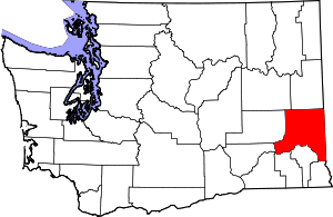 Map of Washington highlighting Whitman County | |
| Towns | ||
| CDP | ||
| Other unincorporated communities | ||
| Ghost towns | ||