Maine State Route 142
State Route 142 (SR 142) is a numbered state highway in the U.S. state of Maine that runs from U.S. Route 2 (US 2) and SR 17 in Dixfield to SR 16 and SR 27 in Kingfield.
| ||||
|---|---|---|---|---|
 | ||||
| Route information | ||||
| Maintained by MaineDOT | ||||
| Length | 42.86 mi[1] (68.98 km) | |||
| Existed | 1925–present | |||
| Major junctions | ||||
| South end | ||||
| North end | ||||
| Location | ||||
| Counties | Oxford, Franklin | |||
| Highway system | ||||
| ||||

Route description
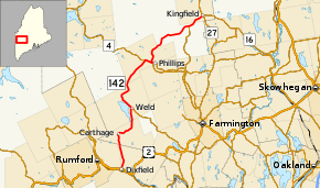
The route begins at its southern terminus in Dixfield. It heads north through Carthage before turning left at SR 156 in Weld. It goes north again before turning right onto a 1.3-mile-long (2.1 km) concurrency with SR 4 in Phillips. It turns left twice there before going northwest to Kingfield, then another left turn leads to the route's northern terminus.[2]
Major junctions
| County | Location | mi[1] | km | Destinations | Notes |
|---|---|---|---|---|---|
| Oxford | Dixfield | 0.00 | 0.00 | ||
| Franklin | Weld | 14.01 | 22.55 | Western terminus of SR 156 | |
| Phillips | 26.15 | 42.08 | Southern end of SR 4 concurrency | ||
| 27.45 | 44.18 | Northern end of SR 4 concurrency | |||
| 27.53 | 44.31 | Western terminus of SR 149 | |||
| East Central Franklin | 39.23 | 63.13 | Northern terminus of SR 145 | ||
| Kingfield | 42.86 | 68.98 | |||
1.000 mi = 1.609 km; 1.000 km = 0.621 mi
| |||||
gollark: Ideatic apioforms in meta-ubqvian space.
gollark: It MIGHT not be.
gollark: [EXPUNGEMENT EXPUNGED]
gollark: CEASE doing things.
gollark: One of my many GTech™ GPowers™.
References
- "Maine DOT Map Viewer". Maine Office of GIS. Retrieved August 4, 2017.
- Google (August 4, 2017). "Maine State Route 142" (Map). Google Maps. Google. Retrieved August 4, 2017.
External links
- "Maine State Route 142". Floodgap. Retrieved 2016-09-13.
This article is issued from Wikipedia. The text is licensed under Creative Commons - Attribution - Sharealike. Additional terms may apply for the media files.