Maine State Route 141
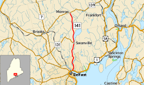
State Route 141 (SR 141) is a route from U.S. Route 1 (US 1) and SR 3 in Belfast to SR 139 in Monroe. The route's entire length is in Waldo County.
| ||||
|---|---|---|---|---|
 | ||||
| Route information | ||||
| Maintained by MaineDOT | ||||
| Length | 13.17 mi[1] (21.20 km) | |||
| Existed | 1925–present | |||
| Major junctions | ||||
| South end | ||||
| North end | ||||
| Location | ||||
| Counties | Waldo | |||
| Highway system | ||||
| ||||

Junction list
The entire route is in Waldo County.
| Location | mi[1] | km | Destinations | Notes | |
|---|---|---|---|---|---|
| Belfast | 0.00 | 0.00 | |||
| Swanville | 6.48 | 10.43 | Northern terminus of SR 131 | ||
| Monroe | 13.17 | 21.20 | |||
| 1.000 mi = 1.609 km; 1.000 km = 0.621 mi | |||||
gollark: What is this *for* anyway? Cryptography is very ÆÆÆÆÆÆÆææÆÆÆææÆÆæÆÆÆÆÆÆÆÆÆÆÆæææ to get right, so I would mostly recommend just using existing stuff like TLS.
gollark: Oh, we intercept all their data just after it gets sent.
gollark: There are other key exchange things like diffe-hellman which are good somehow?!
gollark: Blog posts are incapable of lies.
gollark: https://blog.trailofbits.com/2019/07/08/fuck-rsa/
References
- Maine DOT Map Viewer (Map). Maine Office of GIS. Retrieved October 14, 2017.
External links
This article is issued from Wikipedia. The text is licensed under Creative Commons - Attribution - Sharealike. Additional terms may apply for the media files.