Maine State Route 145
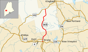
State Route 145 (SR 145) is part of Maine's system of numbered state highways. It runs ten miles (16 km) from an intersection with SR 4 in Strong to an intersection with SR 142 near Kingfield. The route is also known as Main Street in Strong.[2]
| ||||
|---|---|---|---|---|
 | ||||
| Route information | ||||
| Maintained by MaineDOT | ||||
| Length | 10.03 mi[1] (16.14 km) | |||
| Existed | 1925–present | |||
| Major junctions | ||||
| South end | ||||
| North end | ||||
| Location | ||||
| Counties | Franklin | |||
| Highway system | ||||
| ||||

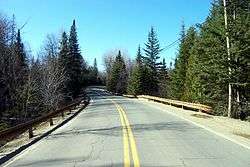
Route 145 facing northbound in Freeman Township
Major junctions
The entire route is in Franklin County.
| Location | mi[1] | km | Destinations | Notes | |
|---|---|---|---|---|---|
| Strong | 0.00 | 0.00 | |||
| 0.40 | 0.64 | Western terminus of SR 234 | |||
| East Central Franklin | 10.03 | 16.14 | |||
| 1.000 mi = 1.609 km; 1.000 km = 0.621 mi | |||||
gollark: That's actually a great idea. The link table is already there, so it can look at that, prefetch all the relevant alias/page existence data, and use that in the render phase.
gollark: There's a table in the database with a bunch of links in and out.
gollark: Oh, it does do that.
gollark: Thus, WHAT DO?!?!?!?!
gollark: However, this would require more complex code and possibly make rendering generally slower.
References
- "Maine DOT Map Viewer". Maine Office of GIS. Retrieved August 6, 2017.
- Google (August 6, 2017). "Maine State Route 145" (Map). Google Maps. Google. Retrieved August 6, 2017.
External links
This article is issued from Wikipedia. The text is licensed under Creative Commons - Attribution - Sharealike. Additional terms may apply for the media files.